IMAGES TAKEN NEAR TO
Gotheridge Drive, NG4 4NE
Introduction
This page details the photographs taken nearby to Gotheridge Drive, NG4 4NE by members of the Geograph project.
The Geograph project started in 2005 with the aim of publishing, organising and preserving representative images for every square kilometre of Great Britain, Ireland and the Isle of Man.

There are currently over 7.5m images from over14,400 individuals and you can help contribute to the project by visiting https://www.geograph.org.uk
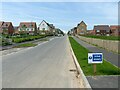
Image Map
Images are licensed for reuse under creativecommons.org/licenses/by-sa/2.0
Notes
- Clicking on the map will re-center to the selected point.
- The higher the marker number, the further away the image location is from the centre of the postcode.
Image Listing (65 Images Found)
Images are licensed for reuse under creativecommons.org/licenses/by-sa/2.0
Image
Details
Distance
1
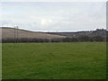
Field alongside Arnold Lane
The prominent hill to the left is the spoil heap of the former Gedling Colliery which lay behind the hedge to the right hand side of the picture.
Image: © Alan Murray-Rust
Taken: 1 Feb 2009
0.04 miles

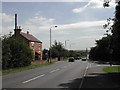
3
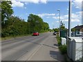
Arnold Lane, Gedling
Currently the A 6211, a major suburban through route, shortly to be superseded by the new Gedling Access Road.
Image: © Alan Murray-Rust
Taken: 30 May 2020
0.09 miles
4
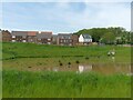
Attenuation pond, Chase Farm
The muddiness of the water is due to the fact that it is draining off the continuing construction area, with plenty of mud on the roads.
Image: © Alan Murray-Rust
Taken: 14 May 2023
0.11 miles
5
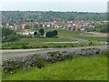
View towards Chase Farm from the beacon
An update on https://www.geograph.org.uk/photo/7054775 from 18 months earlier.
Image: © Alan Murray-Rust
Taken: 14 May 2023
0.11 miles
6
Harviston Avenue, Chase Farm
This forms the main spine road of the estate. As the estate is still under construction, a final tarmac surface layer has yet to be applied and the road is subject to a (nominal!) 10 mph limit.
Image: © Alan Murray-Rust
Taken: 14 May 2023
0.12 miles
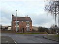
7
Scotgrave Farm on Arnold Lane, Gedling
Opposite the farm is the junction of Shelford Rd.
Image: © Tom Courtney
Taken: 9 Aug 2005
0.16 miles
8
Scot Grave Farm
On Arnold Lane, backing onto the old Gedling Colliery site.
Image: © Alan Murray-Rust
Taken: 1 Feb 2009
0.16 miles
9
Scotgrave Farm on Arnold Lane, Gedling
Recreating this 'First' for the square http://www.geograph.org.uk/photo/35580. The old farmhouse is now surrounded by the new Chase Farm development.
Image: © Alan Murray-Rust
Taken: 25 May 2021
0.16 miles
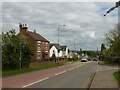
10

Substation on Waldrom Road, Gedling
A major local distribution point, the site doubtless chosen to be close to Gedling Colliery which would have been its major user. Now becoming surrounded by modern housing development.
Image: © Alan Murray-Rust
Taken: 30 May 2020
0.16 miles