IMAGES TAKEN NEAR TO
Babbington Crescent, NOTTINGHAM, NG4 4ER
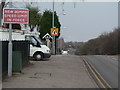
Introduction
This page details the photographs taken nearby to Babbington Crescent, NG4 4ER by members of the Geograph project.
The Geograph project started in 2005 with the aim of publishing, organising and preserving representative images for every square kilometre of Great Britain, Ireland and the Isle of Man.

There are currently over 7.5m images from over14,400 individuals and you can help contribute to the project by visiting https://www.geograph.org.uk
Image Map
Images are licensed for reuse under creativecommons.org/licenses/by-sa/2.0
Notes
- Clicking on the map will re-center to the selected point.
- The higher the marker number, the further away the image location is from the centre of the postcode.
Image Listing (61 Images Found)
Images are licensed for reuse under creativecommons.org/licenses/by-sa/2.0
Image
Details
Distance
1
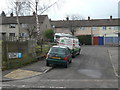
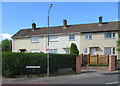
Babbington Crescent
One of several roads in the area named after collieries in Nottinghamshire. The development was essentially a pit village for the neighbouring Gedling Colliery, although it abutted existing residential areas. The colliery was in Image on the site now occupied by Phoenix Park
Image: © Alan Murray-Rust
Taken: 1 Feb 2009
0.01 miles
2
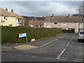
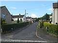
Besecar Avenue
Principal feeder road into the colliery estate built off Arnold Lane in the 1950s/60s.
Image: © Alan Murray-Rust
Taken: 1 Feb 2009
0.03 miles
3
Besecar Avenue, Gedling
Thankfully, this road is only used by Nottingham City Transport bus route 44 (Gedling to city via Netherfield) in one direction as it does a small one way loop around this part of Gedling. The horizon is formed by the slag heaps of Gedling colliery (closed 1991).
Image: © Richard Vince
Taken: 11 Feb 2014
0.04 miles
4
Cinderhill Drive
"One of several roads in the area named after collieries in Nottinghamshire. The development was essentially a pit village for the neighbouring Gedling Colliery, although it abutted existing residential areas. Cinderhill was an alternative name for Babbington Colliery which was in SK5343 on the site now occupied by Phoenix Park
."
Image: © Alan Murray-Rust
Taken: 1 Feb 2009
0.06 miles
5
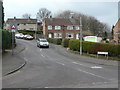
Gedling: the corner of Wollaton Avenue
Gedling was a colliery village, and some of its streets were named after other Nottinghamshire pits. The original ground-level road sign has been replaced by a more conventional one. Alan Murray-Rust's Image] and Image] show two more of this unusual type.
Image: © John Sutton
Taken: 3 Jun 2015
0.06 miles
6
Gedling: Hucknall Crescent
Gedling was a colliery village and a number of its post-War streets were named after other Nottinghamshire pits.
Image: © John Sutton
Taken: 3 Jun 2015
0.06 miles
7
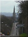
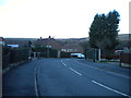
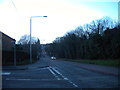
Ups and downs of Arnold Lane
A real roller-coaster road. The spire of Gedling church is an ever-present landmark in this area.
Image: © Alan Murray-Rust
Taken: 1 Feb 2009
0.08 miles
8
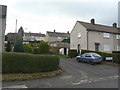
Hucknall Crescent
One of several roads in the area named after collieries in Nottinghamshire. The development was essentially a pit village for the neighbouring Gedling Colliery, although it abutted existing residential areas. Hucknall Colliery was in Image, in the bottom left corner next to the railway line.
Image: © Alan Murray-Rust
Taken: 1 Feb 2009
0.08 miles
9
Speed limit sign
The change from 30 to 40 mph has been moved about 100 metres further along so that the 30 mph section now includes this blind summit and the important road junction signed.
Image: © Alan Murray-Rust
Taken: 1 Feb 2009
0.09 miles
10
Arnold Lane, Gedling
Looking towards Arnold from the end of Besecar Avenue, Arnold Lane looks almost like a straight rollercoaster, epitomising the hilly nature of this part of Gedling.
Image: © Richard Vince
Taken: 11 Feb 2014
0.09 miles