IMAGES TAKEN NEAR TO
Curzon Street, NOTTINGHAM, NG4 2NR
Introduction
This page details the photographs taken nearby to Curzon Street, NG4 2NR by members of the Geograph project.
The Geograph project started in 2005 with the aim of publishing, organising and preserving representative images for every square kilometre of Great Britain, Ireland and the Isle of Man.

There are currently over 7.5m images from over14,400 individuals and you can help contribute to the project by visiting https://www.geograph.org.uk
Image Map
Images are licensed for reuse under creativecommons.org/licenses/by-sa/2.0
Notes
- Clicking on the map will re-center to the selected point.
- The higher the marker number, the further away the image location is from the centre of the postcode.
Image Listing (23 Images Found)
Images are licensed for reuse under creativecommons.org/licenses/by-sa/2.0
Image
Details
Distance
2
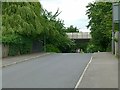
Bridge over the Ouse Dyke, Chandos Street
The road rises considerably to cross what is quite a small stream. There is a bench mark http://www.geograph.org.uk/photo/5024102on the parapet to the left.
Image: © Alan Murray-Rust
Taken: 4 Jul 2016
0.12 miles
4
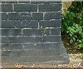
Bench mark, Bridge over the Ouse Dyke, Chandos Street
See http://www.geograph.org.uk/photo/5024100 for location.
Image: © Alan Murray-Rust
Taken: 4 Jul 2016
0.13 miles
5
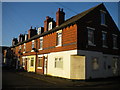
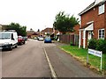
Housing on Cross Street, Gedling
The house at this end of the terrace appears to have been a corner shop in the past.
Image: © Richard Vince
Taken: 11 Feb 2014
0.13 miles
6
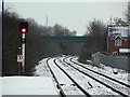
Looking east from carlton Station
On the Nottingham to Lincoln line. The station was formerly called Carlton and Netherfield and is in Netherfield rather than Carlton. The renaming distinguishes it from Netherfield Station, formerly Netherfield and Colwick.
Image: © Alan Murray-Rust
Taken: 2 Feb 2009
0.19 miles
7
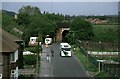
Bus on Chandos Street, Netherfield – 1986
In the run-up to the deregulation of bus services in October 1986, City of Nottingham Transport introduced a series of ‘Accessline’ services using small buses to reach areas that could not be served by full size buses. The idea was that these areas would not be attractive to possible competitors after deregulation and that passengers would be attracted to use these localised services rather than walk to main roads. These services were never economically viable and in most cases services were withdrawn soon after deregulation and have not been replaced since.
Chandos Street is one of the few sections where a limited service has been maintained, although the route is substantially different from the Accessline service.
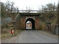
The railway bridge carried the line up to Gedling Colliery, at that time still operational. Originally it formed part of the Great Northern Railway’s very roundabout route from Nottingham to Derby, via Colwick, Basford, and Ilkeston.
Image: © Alan Murray-Rust
Taken: 1 May 1986
0.20 miles
8
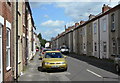
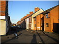
Curzon Street, Netherfield
Taken specifically for comparison with the image in Domesday Reloaded http://www.bbc.co.uk/history/domesday/dblock/GB-460000-339000/picture/1 . As the caption there states, this is a typical Netherfield Street, and it took a bit of research to decide exactly which street it was. The taller building just visible further down the left hand side of the street in the older picture (possibly industrial premises) has now been replaced with more modern housing.
The main change is the increase in the number of parked cars.
Image: © Alan Murray-Rust
Taken: 24 May 2011
0.21 miles
10
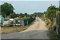
Stoke Lane allotments
Seen from the footpath which alongside the western edge.
Image: © Alan Murray-Rust
Taken: 24 May 2010
0.22 miles