IMAGES TAKEN NEAR TO
Festus Street, NOTTINGHAM, NG4 2LN
Introduction
This page details the photographs taken nearby to Festus Street, NG4 2LN by members of the Geograph project.
The Geograph project started in 2005 with the aim of publishing, organising and preserving representative images for every square kilometre of Great Britain, Ireland and the Isle of Man.

There are currently over 7.5m images from over14,400 individuals and you can help contribute to the project by visiting https://www.geograph.org.uk
Image Map
Images are licensed for reuse under creativecommons.org/licenses/by-sa/2.0
Notes
- Clicking on the map will re-center to the selected point.
- The higher the marker number, the further away the image location is from the centre of the postcode.
Image Listing (46 Images Found)
Images are licensed for reuse under creativecommons.org/licenses/by-sa/2.0
Image
Details
Distance
1
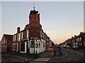
Tower on the corner of Kenrick Street and Chandos Street
Former Ceylon Tea House. The tower once housed a bell.
Image: © Jonathan Thacker
Taken: 7 Dec 2015
0.09 miles
3
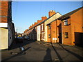
Curzon Street, Netherfield
Taken specifically for comparison with the image in Domesday Reloaded http://www.bbc.co.uk/history/domesday/dblock/GB-460000-339000/picture/1 . As the caption there states, this is a typical Netherfield Street, and it took a bit of research to decide exactly which street it was. The taller building just visible further down the left hand side of the street in the older picture (possibly industrial premises) has now been replaced with more modern housing.
The main change is the increase in the number of parked cars.
Image: © Alan Murray-Rust
Taken: 24 May 2011
0.10 miles
4
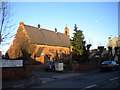
Church of St George the Martyr, Victoria Road, Netherfield
Image: © Richard Vince
Taken: 11 Feb 2014
0.10 miles
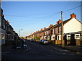
5
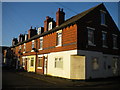
Housing on Cross Street, Gedling
The house at this end of the terrace appears to have been a corner shop in the past.
Image: © Richard Vince
Taken: 11 Feb 2014
0.11 miles
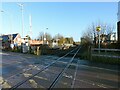
6
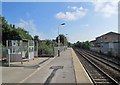
Carlton Station: eastbound platform
This is the former Midland Railway line to Newark and Lincoln. The platforms at Carlton (formerly Carlton & Netherfield) are staggered rather than opposite each other - the westbound platform is behind the camera, on the other side of the level crossing. The waiting shelter stands on the site of the pretty cottage-style station building, demolished in the 1960s.
Image: © John Sutton
Taken: 22 Aug 2013
0.11 miles
7
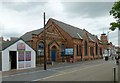
Netherfield Baptist Chapel
Dated 1892. The smaller building appears to have been the actual chapel, the larger being a hall.
Image: © Alan Murray-Rust
Taken: 4 Jul 2016
0.12 miles
8
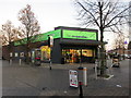
Co-op store, Netherfield
In the centre of the shopping area.
Image: © Jonathan Thacker
Taken: 7 Dec 2015
0.12 miles
9
Carlton Station
Due to space considerations, the station has always been laid out with staggered platforms.
Image: © Alan Murray-Rust
Taken: 17 Dec 2020
0.12 miles