IMAGES TAKEN NEAR TO
Pool Meadow, NOTTINGHAM, NG4 2DF
Introduction
This page details the photographs taken nearby to Pool Meadow, NG4 2DF by members of the Geograph project.
The Geograph project started in 2005 with the aim of publishing, organising and preserving representative images for every square kilometre of Great Britain, Ireland and the Isle of Man.

There are currently over 7.5m images from over14,400 individuals and you can help contribute to the project by visiting https://www.geograph.org.uk
Image Map
Images are licensed for reuse under creativecommons.org/licenses/by-sa/2.0
Notes
- Clicking on the map will re-center to the selected point.
- The higher the marker number, the further away the image location is from the centre of the postcode.
Image Listing (53 Images Found)
Images are licensed for reuse under creativecommons.org/licenses/by-sa/2.0
Image
Details
Distance
1
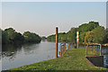
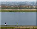
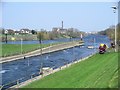
The Trent below Holme Lock
Water from the white-water course at the National Water Sports Centre rejoins the Trent to the right of the railings at the end of this neck of land below the lock. A building at Colwick Industrial Estate shows in the distance, at the next bend in the river.
Image: © John Sutton
Taken: 28 May 2016
0.07 miles
2
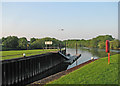
The channel below Holme Lock
This large and deep lock (offstage left), constructed in 1921, allowed big barges from Hull to reach Nottingham.
Image: © John Sutton
Taken: 28 May 2016
0.11 miles
3
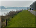
Path next to the Regatta Rowing Lake
At the Holme Pierrepont National Watersports Centre.
Image: © Mat Fascione
Taken: 12 Mar 2016
0.11 miles
4
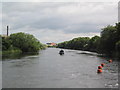
Barge on the Trent approaching Holme Lock
The chimney on the left is part of the derelict Colwick sugar factory. The buoys on the right mark the exit of strong currents from the Holme Pierrepont white water course.
Image: © Tim Heaton
Taken: 29 Jun 2008
0.13 miles
5
Holme Pierrepont National Watersports Centre
The houses in the distance are in Carlton, Nottingham.
Image: © Mat Fascione
Taken: 12 Mar 2016
0.13 miles
6
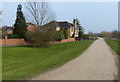
Houses and path next to the River Trent
The houses are on Musters Croft in the Colwick area of Nottingham.
Image: © Mat Fascione
Taken: 12 Mar 2016
0.14 miles
7
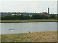
View from the hill
This bit of raised ground appears to have been created from material removed when creating the National Water Sports centre, the main regatta course of which can be seen here. Also visible is the long-derelict sugar factory at Colwick.
Image: © Alan Murray-Rust
Taken: 2 Jul 2009
0.14 miles
8
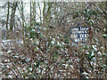
Hooked up
Fishing club notice in the brambles. Colwick Park seems a surprisingly distant location for waters to belong to a club based in Long Eaton, well to the west of Nottingham.
Image: © Alan Murray-Rust
Taken: 2 Feb 2009
0.16 miles
9
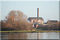
End of the white water course, National Watersports Centre
The end of the canoe slalom/rafting course where it rejoins the river Trent. For more information about the National Watersports Centre, see http://www.nationalwatersportsevents.co.uk/v4/res_website.asp?supplierCode=nwc100 The building with the tall chimney, across the river, is the derelict Colwick sugar factory.
Image: © Lynne Kirton
Taken: 1 Apr 2007
0.16 miles
10
. . . such sweet sorrow
The remains of Colwick sugar factory are seen across Colwick Country Park
Image: © Alan Murray-Rust
Taken: 6 Jan 2008
0.17 miles