IMAGES TAKEN NEAR TO
Kilnwood Close, NOTTINGHAM, NG3 7AZ
Introduction
This page details the photographs taken nearby to Kilnwood Close, NG3 7AZ by members of the Geograph project.
The Geograph project started in 2005 with the aim of publishing, organising and preserving representative images for every square kilometre of Great Britain, Ireland and the Isle of Man.

There are currently over 7.5m images from over14,400 individuals and you can help contribute to the project by visiting https://www.geograph.org.uk
Image Map
Images are licensed for reuse under creativecommons.org/licenses/by-sa/2.0
Notes
- Clicking on the map will re-center to the selected point.
- The higher the marker number, the further away the image location is from the centre of the postcode.
Image Listing (33 Images Found)
Images are licensed for reuse under creativecommons.org/licenses/by-sa/2.0
Image
Details
Distance
1
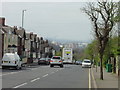
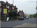
The view down Carlton Road
Carlton Road is a fairly long continuous drag up from the City Centre. The location of Nottingham at the edge of the Trent Valley, which stretches into the distance, can be well seen.
Image: © Alan Murray-Rust
Taken: 27 Apr 2008
0.06 miles
2
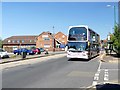
Carlton Road
A Nottingham City Transport bus is passing the Midlands Academy of Dance and Drama (M.A.D.D.)
Image: © Graham Hogg
Taken: 19 Jul 2016
0.07 miles
3
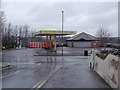
Open 7 days a week
Except on New Year's Day.
Image: © Alan Murray-Rust
Taken: 1 Jan 2014
0.09 miles
4
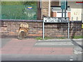
Boundary Pillar 1877 - take 2
Take 1 dates from 2008 http://www.geograph.org.uk/photo/779963
A couple of years ago the pillar was set upright and repainted, but I have only just got round to retaking it. The paintwork is already losing its pristine whiteness.
Image: © Alan Murray-Rust
Taken: 1 Jan 2014
0.11 miles
5
Boundary sign 2008
This will certainly not be here in 111 years' time, unlike Image on the opposite side of the road
Image: © Alan Murray-Rust
Taken: 27 Apr 2008
0.11 miles
6
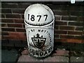
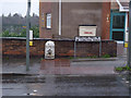
Old Boundary Marker on Carlton Road
Municipal Boundary Marker on the north side of the junction of the B686 Carlton Road and Brentcliffe Avenue, Nottingham. Previously this marked the boundary of Nottingham parish, Nottingham borough and Carlton parish, now City of Nottingham and Gedling parish. In raised lettering 1877 / BOROUGH OF NOTTINGHAM / (escutcheon) / BOUNDARY. See also http://www.geograph.org.uk/photo/3797263 and https://www.geograph.org.uk/photo/779963.
Milestone Society National ID: NT_NOT02pb
Image: © N Osmond
Taken: 17 Jan 2021
0.11 miles
7
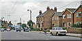
Approaching Nottingham on A612
The A612 used to enter Nottingham via Carlton. This is the view at the top of Carlton Hill. Note the trolleybus wires. (My Morris Oxford on right).
Image: © Ben Brooksbank
Taken: 13 Jul 1963
0.12 miles
8
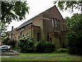
St Cyprian's Church, Sneinton
Built in 1935 by the architect C.E. Howitt
Image: © Andrew Abbott
Taken: 6 Sep 2008
0.12 miles
9
Boundary pillar 1877
Another of the fine cast iron boundary posts of the then Borough of Nottingham. It makes an interesting contrast with the modern style of marking the boundary Image The road name changes here as well.
Image: © Alan Murray-Rust
Taken: 27 Apr 2008
0.13 miles
10
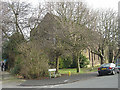
St Cyprians Church
A rather nondescript brick-built church of the mid-1930s, it is difficult to photograph due to the surrounding trees. A summer view would be even less informative!
Image: © Alan Murray-Rust
Taken: 27 Jan 2008
0.13 miles