IMAGES TAKEN NEAR TO
Grover Avenue, NOTTINGHAM, NG3 6DJ
Introduction
This page details the photographs taken nearby to Grover Avenue, NG3 6DJ by members of the Geograph project.
The Geograph project started in 2005 with the aim of publishing, organising and preserving representative images for every square kilometre of Great Britain, Ireland and the Isle of Man.

There are currently over 7.5m images from over14,400 individuals and you can help contribute to the project by visiting https://www.geograph.org.uk
Image Map
Images are licensed for reuse under creativecommons.org/licenses/by-sa/2.0
Notes
- Clicking on the map will re-center to the selected point.
- The higher the marker number, the further away the image location is from the centre of the postcode.
Image Listing (21 Images Found)
Images are licensed for reuse under creativecommons.org/licenses/by-sa/2.0
Image
Details
Distance
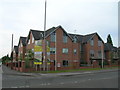
1
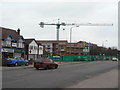
New homes for the elderly
Development on Mapperley Plains at the corner of Hazel Grove.
Image: © Alan Murray-Rust
Taken: 1 Feb 2009
0.15 miles
2

Plains Road, Mapperley
Looking towards Nottingham.
Image: © Alan Murray-Rust
Taken: 1 Feb 2009
0.16 miles
3
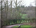
Central Avenue Vicinity, Mapperley Plains, Notts.
The view of the start (or end) of a footpath/bridleway, seen from obliquely opposite the gates of Mapperley Plains Junior School. This combined footpath/bridleway continues downhill in the direction of Mapperley Recreation Ground.
Image: © David Hallam-Jones
Taken: 1 Jan 2016
0.16 miles
4
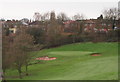
Golf Course, Mapperley Plains, Notts.
A view across part of Mapperley Golf Course. The houses in the distance seem likely to be properties on Hazel Grove and/or Digby Avenue.
Image: © David Hallam-Jones
Taken: 1 Jan 2016
0.17 miles
5
Central Avenue, Mapperley Plains, Notts.
With Plains Road, i.e. the B684 (Nottingham to Dorket Head road) 150 metres behind the photographer, this is a cul-de-sac that providing access to Mapperley Golf Club and the Mapperley Plains Junior School only. Behind the waist-high, black-painted bollard however, a combined footpath and bridleway drops away - downhill - towards Mapperley Recreation Ground.
Image: © David Hallam-Jones
Taken: 1 Jan 2016
0.18 miles
6

Morning traffic on Plains Road
Going-to-work time on a Monday morning in June.
Image: © John Sutton
Taken: 23 Jun 2014
0.18 miles
8
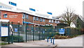
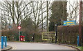
Central Avenue, Mapperley Plains, Notts.
Ahead is the approach road leading to Mapperley Golf Club (500 metres ahead) and on the left is Mapperley Plains Primary School.
Image: © David Hallam-Jones
Taken: 1 Jan 2016
0.20 miles
9
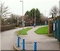
Central Avenue, Mapperley Plains, Notts.
This is the view that someone leaving either Mapperley Golf Club or Mapperley Plains Junior School would see as they approach Plains Road, i.e. the B684 (Nottingham to Dorket Head road) 150 metres ahead (round the right hand bend). Behind the photographer Central Avenue is a dead end from in front of the Golf Club's clubhouse. This photo was taken from the school's main gates. On the left, just behind the middle lamp post is a combined footpath and bridleway that drops away - downhill - towards Mapperley Recreation Ground.
Image: © David Hallam-Jones
Taken: 1 Jan 2016
0.20 miles
10
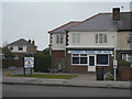
Roadside snacks
The British ingenuity with language strikes again!
Image: © Alan Murray-Rust
Taken: 1 Feb 2009
0.20 miles