IMAGES TAKEN NEAR TO
Dawlish Close, NOTTINGHAM, NG3 5UR
Introduction
This page details the photographs taken nearby to Dawlish Close, NG3 5UR by members of the Geograph project.
The Geograph project started in 2005 with the aim of publishing, organising and preserving representative images for every square kilometre of Great Britain, Ireland and the Isle of Man.

There are currently over 7.5m images from over14,400 individuals and you can help contribute to the project by visiting https://www.geograph.org.uk
Image Map
Images are licensed for reuse under creativecommons.org/licenses/by-sa/2.0
Notes
- Clicking on the map will re-center to the selected point.
- The higher the marker number, the further away the image location is from the centre of the postcode.
Image Listing (18 Images Found)
Images are licensed for reuse under creativecommons.org/licenses/by-sa/2.0
Image
Details
Distance
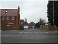
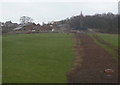
1

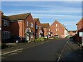
Red and blue
Modern housing alongside Gedling Country Park.
Image: © Alan Murray-Rust
Taken: 26 Apr 2021
0.07 miles
2
Orchard Park
Modern housing development off Mapperley Plains, replacing orchard and gardens.
Image: © Alan Murray-Rust
Taken: 1 Feb 2009
0.12 miles
3
Chartwell Grove
Modern housing development off Mapperley Plains. This area was previously the landsale wharf for Gedling Colliery.
Image: © Alan Murray-Rust
Taken: 1 Feb 2009
0.17 miles
4
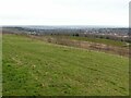
Gedling Country Park at Christmas 2021 ? 2
View into the Trent Valley from one of the high points of the country park.
Image: © Alan Murray-Rust
Taken: 25 Dec 2021
0.18 miles
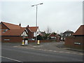
5
Mapperley Plains
A ridge route leading from Nottingham to Woodborough and Calverton, with the development of housing to the east of Nottingham it is now a major exit towards the north.
Image: © Alan Murray-Rust
Taken: 1 Feb 2009
0.19 miles
6
Axmouth Drive, Mapperley Plains
Part of the most recent, 21st century, housing development along Spring Lane.
Image: © Alan Murray-Rust
Taken: 22 Nov 2020
0.20 miles
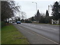
7
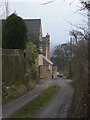
Lane to Chase Farm
Modern housing off Mapperley Plains is now intruding on the scene.
Image: © Alan Murray-Rust
Taken: 1 Feb 2009
0.21 miles
8
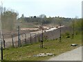
Gedling Access Road construction
Looking towards the link to Arnold Lane.
Image: © Alan Murray-Rust
Taken: 26 Apr 2021
0.21 miles
9
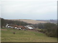
Chase Farm
This has been a green oasis between the residential area of Mapperley and the former Gedling Colliery, the spoil heap of which dominates the skyline. This area is now earmarked for a major residential development of around 3500 homes, with corresponding commercial developments.
Image: © Alan Murray-Rust
Taken: 1 Feb 2009
0.22 miles
10
Chase Farm
Seen from Arnold Lane. The dug strip appears to be drainage from new housing development behind the farm.
Image: © Alan Murray-Rust
Taken: 1 Feb 2009
0.22 miles