IMAGES TAKEN NEAR TO
Gordon Rise, NOTTINGHAM, NG3 5GB
Introduction
This page details the photographs taken nearby to Gordon Rise, NG3 5GB by members of the Geograph project.
The Geograph project started in 2005 with the aim of publishing, organising and preserving representative images for every square kilometre of Great Britain, Ireland and the Isle of Man.

There are currently over 7.5m images from over14,400 individuals and you can help contribute to the project by visiting https://www.geograph.org.uk
Image Map
Images are licensed for reuse under creativecommons.org/licenses/by-sa/2.0
Notes
- Clicking on the map will re-center to the selected point.
- The higher the marker number, the further away the image location is from the centre of the postcode.
Image Listing (71 Images Found)
Images are licensed for reuse under creativecommons.org/licenses/by-sa/2.0
Image
Details
Distance
1
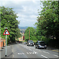
Mapperley Rise
Looking down this steep road which links Sherwood and Mapperley Top. The east of the city is hilly and there is a long view across Sherwood and Basford to the hills beyond Strelley which separate Nottingham from the Erewash Valley.
Image: © John Sutton
Taken: 17 Jun 2014
0.04 miles
2
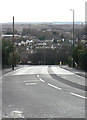
Mapperley Rise
Or more appropriately 'descent' in this direction. One of the many steep roads in the north east sector of Nottingham resulting from the heavily incised valleys in the local mudstones. It links Mapperley (on top) with Sherwood below.
Image: © Alan Murray-Rust
Taken: 8 Mar 2009
0.04 miles
3
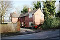
No. 54 Mapperley Rise
Ordnance Survey documents indicate that a cut mark benchmark was levelled at 104.812m above Newlyn Datum in 1962 on the right hand corner of the house
Image: © Luke Shaw
Taken: 1 Feb 2020
0.05 miles
4
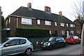
Nos. 34 to 28 (evens) Morley Avenue
Ordnance Survey documents indicate that a benchmark was levelled at 116.778m above Newlyn Datum in 1962 on the side of the left hand house at its front corner
Image: © Luke Shaw
Taken: 1 Feb 2020
0.05 miles
5
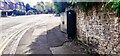
Mapperley Rise (opposite #70) at Cresta Gardens junction
There is an Ordnance Survey benchmark Image on the wall behind the green cabinet
Image: © Roger Templeman
Taken: 8 May 2022
0.06 miles
6
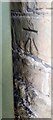
Benchmark behind cabinet on SW side of Mapperley Rise
Ordnance Survey cut mark benchmark levelled at 92.345m above Newlyn Datum verified 1962
Image: © Roger Templeman
Taken: 8 May 2022
0.07 miles
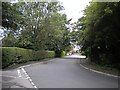
7
Hill View Avenue, Mapperley
Seen from Private Road, the reason for its name is fairly obvious. The land also slopes away quite steeply behind the houses on the right.
Image: © Richard Vince
Taken: 14 Jul 2012
0.07 miles
8

Nos. 70 & 68 Mapperley Rise at Sherwood Rise junction
Image: © Roger Templeman
Taken: 1 Feb 2020
0.07 miles
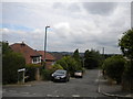
9
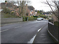
Gordon Rise, Mapperley
Seen from Private Road (which actually continues as the turning to the left in the foreground), Gordon Rise appears unpopulated. However, it is surrounding by housing, albeit at a different level from the road at this point.
Image: © Richard Vince
Taken: 14 Jul 2012
0.08 miles
10
Sherwood Vale railway bridge
The bridge was over the old Nottingham Suburban railway.
Image: © Alan Murray-Rust
Taken: 8 Mar 2009
0.09 miles