IMAGES TAKEN NEAR TO
Park View, NOTTINGHAM, NG3 5FD
Introduction
This page details the photographs taken nearby to Park View, NG3 5FD by members of the Geograph project.
The Geograph project started in 2005 with the aim of publishing, organising and preserving representative images for every square kilometre of Great Britain, Ireland and the Isle of Man.

There are currently over 7.5m images from over14,400 individuals and you can help contribute to the project by visiting https://www.geograph.org.uk
Image Map
Images are licensed for reuse under creativecommons.org/licenses/by-sa/2.0
Notes
- Clicking on the map will re-center to the selected point.
- The higher the marker number, the further away the image location is from the centre of the postcode.
Image Listing (78 Images Found)
Images are licensed for reuse under creativecommons.org/licenses/by-sa/2.0
Image
Details
Distance
1
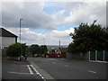
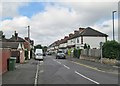
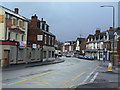
Looking down Mapperley Rise
At this point, Mapperley Rise begins to descend gently from Woodborough Road (behind the photographer) towards Sherwood; the descent becomes alarmingly steep a little further on.
Image: © Richard Vince
Taken: 14 Jul 2012
0.07 miles
2
Junction of Mapperley Rise / Morley Avenue
There is an Ordnance Survey benchmark Image on the stone wall at the junction about 1 foot left of the white-painted section
Image: © Luke Shaw
Taken: 1 Feb 2020
0.08 miles
3
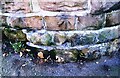
Benchmark on wall at Mapperley Rise / Morley Avenue junction
Ordnance Survey cut mark benchmark levelled at 122.563m above Newlyn Datum in 1962
Image: © Luke Shaw
Taken: 1 Feb 2020
0.08 miles
4

Display of patriotism
. . . and second hand cars.
Showroom on Woodborough Road, Mapperley.
Image: © Alan Murray-Rust
Taken: 8 Mar 2009
0.09 miles
5
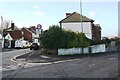
Maurice Drive, Mapperley
A residential cul de sac off Mapperley Rise.
Image: © Richard Vince
Taken: 14 Jul 2012
0.09 miles
6
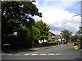
Mapperley: Morley Avenue
Off Mapperley Rise, just north of Woodborough Road on the hilly eastern side of the city.
Image: © John Sutton
Taken: 17 Jun 2014
0.09 miles
7
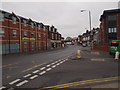
Nottingham - Mapperley NG3
A stretch of the B684 (Woodborough Rd) running in the direction of Nottingham city centre. The rear of a bus is visible on Mapperley Rise, commencing its descent down the hill that leads to the suburb of Sherwood. Opposite the entrance/exit into Mapperley Rise the "Belle Vue" residential home for the care of individuals with dementia (opened in 2011) - on the site of the old "Belle Vue" pub - can be seen.
Image: © David Hallam-Jones
Taken: 16 Mar 2012
0.09 miles
8
Nottingham - Mapperley NG3
A view along Woodborough Road (B684) in the direction of the suburb of Mapperley, i.e. away from Nottingham city centre. The "Belle Vue" Care Home for elderly individuals suffering with dementia that opened in 2011 can be seen in the distance on the right-hand side of the picture. The care home was constructed on the site of the demolished Belle Vue pub.
Image: © David Hallam-Jones
Taken: 16 Mar 2012
0.09 miles
9
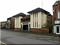
The former Majestic Cinema, Mapperley
Much has happened since I photographed the building in 2009 https://www.geograph.org.uk/photo/1197724 . By around 2018 it was occupied by The Haunted Museum, but this closed in 2020 due to the Covid pandemic. Permanent closure was announced in 2021 due to the condition of the building, the Museum having moved to new premises.
2020 also saw the Listing (Grade II) of the building by Historic England https://historicengland.org.uk/listing/the-list/list-entry/1472567 which will be a constraint on any new occupier. The building remained unoccupied at the time of this visit, but this has the advantage that the frontage is free of signage, allowing the architecture to express itself.
Image: © Alan Murray-Rust
Taken: 27 Nov 2022
0.11 miles
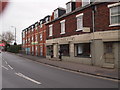
10
Woodborough Road
At the junction with Mapperley Rise.
The Belle Vue at left is one of many looking for new owners. this is a former Shipstones house.
Image: © Alan Murray-Rust
Taken: 8 Mar 2009
0.11 miles