IMAGES TAKEN NEAR TO
Magdala Road, NOTTINGHAM, NG3 5DF
Introduction
This page details the photographs taken nearby to Magdala Road, NG3 5DF by members of the Geograph project.
The Geograph project started in 2005 with the aim of publishing, organising and preserving representative images for every square kilometre of Great Britain, Ireland and the Isle of Man.

There are currently over 7.5m images from over14,400 individuals and you can help contribute to the project by visiting https://www.geograph.org.uk
Image Map
Images are licensed for reuse under creativecommons.org/licenses/by-sa/2.0
Notes
- Clicking on the map will re-center to the selected point.
- The higher the marker number, the further away the image location is from the centre of the postcode.
Image Listing (134 Images Found)
Images are licensed for reuse under creativecommons.org/licenses/by-sa/2.0
Image
Details
Distance
1
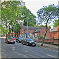
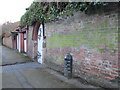
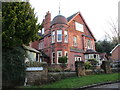
Mapperley Park: Magdala Road
Magdala Road runs up the steep hill from Mansfield Road to Woodborough Road. Some of Nottingham's wealthiest Victorians and Edwardians built huge houses here, many with stables and coachmen's houses like the ones in this picture.
Image: © John Sutton
Taken: 17 Jun 2014
0.01 miles
2
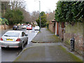
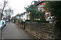
Redcliffe Road, Mapperley Park
At one time this marked the boundary of Nottingham, as indicated by the marker http://www.geograph.org.uk/photo/3903440 on the right.
Image: © Alan Murray-Rust
Taken: 18 Mar 2014
0.05 miles
3
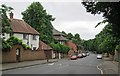
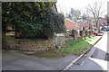
Down Redcliffe Road
Looking down the hill towards Mansfield Road on a dull Sunday morning in mid June.
Image: © John Sutton
Taken: 15 Jun 2014
0.05 miles
4
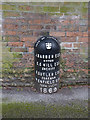
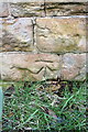
Boundary Marker, Redcliffe Road
In 1869 this was still the municipal boundary. The marker is one of a number erected in connection with Poor Law area boundaries. Listed Grade II. See http://www.geograph.org.uk/photo/3903439 for location.
Image: © Alan Murray-Rust
Taken: 18 Mar 2014
0.05 miles
5
Boundary Marker on Redcliffe Road
Redcliffe Road (then Red Lane) marked the northern boundary of Nottingham prior to boundary extensions in 1877.
Image: © Jonathan Thacker
Taken: 15 Jan 2016
0.05 miles
6
Cyprus Road, Mapperley Park
A typical street in Mapperley Park.
The Mapperley Park and Alexandra Park Conservation Area was first designated in July 1976 and extended in December 1976. This designation recognises its historic significance as an early Edwardian suburb built within a mature parkland setting. The large Conservation Area lies between Mansfield Road and Woodborough Road, extending to the east of Woodborough Road to include Alexandra Park, with its northern boundary generally defined by Private Road and its southern boundary defined by Mapperley Road.
Mapperley Park and Alexandra Park developed as an exclusive suburb for the Edwardian middle classes. Speculatively built and completed over a period of over fifty years, properties display a range of styles from the late 19th through to the mid 20th century. The Conservation Area includes many good quality examples of the range of Vernacular Revival styles that defined the late Victorian and Edwardian periods; with Gothic and other Victorian styles on the edges of the area contrasting with the more homely individualistic styles of the 20th century Vernacular Revival that comprise the core of the estate.
Image: © Kate Jewell
Taken: 3 Jan 2008
0.06 miles
7
Benchmark on Elm Bank Drive wall
Ordnance Survey cut mark benchmark described on the Bench Mark Database at http://www.bench-marks.org.uk/bm47925
Image: © Roger Templeman
Taken: 31 Mar 2013
0.06 miles
8
Junction of Elm Bank Drive and Redcliffe Road
There is an OS benchmark Image at the base of the wall under the Elm Bank Drive name sign
Image: © Roger Templeman
Taken: 31 Mar 2013
0.06 miles
9
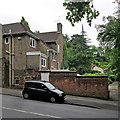
House on the corner of Elm Bank Drive
The part of Nottingham north of Mapperley Road was developed from the 1870s onward as a suburb for the relatively affluent. Many of the older houses are hidden behind high walls and trees. This house is relatively visible. It appears to have been built using local brick and is decorated in part with terracotta.
Image: © Jonathan Thacker
Taken: 15 Jan 2016
0.06 miles
10
On Redcliffe Road
The picture gives an idea of how steep this road which links Mansfield Road and Mapperley and Woodborough Roads is. In the distance on the right is a grand, rather Germanic-looking house, higher up on Mapperley Road.
Image: © John Sutton
Taken: 15 Jun 2014
0.08 miles