1
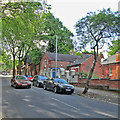
Cyprus Road, Mapperley Park
A typical street in Mapperley Park.
The Mapperley Park and Alexandra Park Conservation Area was first designated in July 1976 and extended in December 1976. This designation recognises its historic significance as an early Edwardian suburb built within a mature parkland setting. The large Conservation Area lies between Mansfield Road and Woodborough Road, extending to the east of Woodborough Road to include Alexandra Park, with its northern boundary generally defined by Private Road and its southern boundary defined by Mapperley Road.
Mapperley Park and Alexandra Park developed as an exclusive suburb for the Edwardian middle classes. Speculatively built and completed over a period of over fifty years, properties display a range of styles from the late 19th through to the mid 20th century. The Conservation Area includes many good quality examples of the range of Vernacular Revival styles that defined the late Victorian and Edwardian periods; with Gothic and other Victorian styles on the edges of the area contrasting with the more homely individualistic styles of the 20th century Vernacular Revival that comprise the core of the estate.
Image: © Kate Jewell
Taken: 3 Jan 2008
0.08 miles
2
Mapperley Park: Magdala Road
Magdala Road runs up the steep hill from Mansfield Road to Woodborough Road. Some of Nottingham's wealthiest Victorians and Edwardians built huge houses here, many with stables and coachmen's houses like the ones in this picture.
Image: © John Sutton
Taken: 17 Jun 2014
0.08 miles
3
Nottingham, NG3 - Mapperley Park
Looking up Elm Bank from Redcliffe Road. Red Lane, as it was known until c.1870, was apparently "inaccessible during the winter months". Therefore, this link with Mapperley Road - if it existed in the 19th century - would have been impossible to ascend. The gates on the right open into the stable block forecourt of Claremont House, the large bay-windowed property.
Image: © David Hallam-Jones
Taken: 4 Nov 2012
0.08 miles
4
Magdala Road, Mapperley Park
Image: © Chris Whippet
Taken: 28 Jul 2015
0.09 miles
5
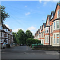
Mapperley Park Drive
Grand terraces line a road linking Magdala Road and Redcliffe Road (ahead).
Image: © John Sutton
Taken: 17 Jun 2014
0.09 miles
6
Nottingham, NG3 - Mapperley Park
Looking along Redcliffe Road in the direction of Mansfield Road (the A60) from Mapperley Road that lies behind the photographer. Red Lane, as it was known until c.1870, was apparently "inaccessible during the winter months". Heavy brick-laden carts descending from Mapperley's brickworks would no doubt have contributed to the damage to this unmade road. On the left is the former coach house of Claremont House situated on neighbouring Elm Bank. The coach house is now a separate property that has been converted into a private house known as "Claremont Stables".
Image: © David Hallam-Jones
Taken: 4 Nov 2012
0.09 miles
7
Claremont Stables, Redcliffe Road
Purpose-built stables and coach-house for a large house called Claremont.http://www.geograph.org.uk/photo/3210559
Image: © Alan Murray-Rust
Taken: 18 Mar 2014
0.09 miles
8
Ebers Road
Looking towards Mansfield Road. The pillar box is a rare E VII R specimen.
Image: © Alan Murray-Rust
Taken: 15 Mar 2009
0.09 miles
9
Down Redcliffe Road
Looking down the hill towards Mansfield Road on a dull Sunday morning in mid June.
Image: © John Sutton
Taken: 15 Jun 2014
0.10 miles
10
Zulla Road, Mapperley Park
Mapperley Park is a Conservation Area with a wealth of late Victorian and Edwardian housing on tree lined streets. Within easy walking distance of the city centre it is a popular area to live and many of the large houses on the south of the "estate" have been converted into flats. Zulla Road, on the south western side, is one of only two roads in the Nottingham area beginning with "Z". The other is Zulu Road a couple of kilometres west in
Image
Many of the roads in Mapperley Park are named after 19th Century military campaigns. Zulla was a small fishing village in Annesley Bay on the Abyssinian coast, (now Ethiopia). The village became the landing point during the 1868 campaign to rescue British hostages from the mountain fortress of Magdala. An account of this campaign, initiated by a "diplomatic incident" between King Theodore II of Abyssinia and the British Government, can be found at http://www.britishempire.co.uk/forces/armycampaigns/africancampaigns/campabyssinia.htm
Zulla Road joins Magdala Road at its southern end.
Image: © Kate Jewell
Taken: 3 Jan 2008
0.10 miles


