IMAGES TAKEN NEAR TO
Elm Bank, NOTTINGHAM, NG3 5AJ
Introduction
This page details the photographs taken nearby to Elm Bank, NG3 5AJ by members of the Geograph project.
The Geograph project started in 2005 with the aim of publishing, organising and preserving representative images for every square kilometre of Great Britain, Ireland and the Isle of Man.

There are currently over 7.5m images from over14,400 individuals and you can help contribute to the project by visiting https://www.geograph.org.uk
Image Map
Images are licensed for reuse under creativecommons.org/licenses/by-sa/2.0
Notes
- Clicking on the map will re-center to the selected point.
- The higher the marker number, the further away the image location is from the centre of the postcode.
Image Listing (175 Images Found)
Images are licensed for reuse under creativecommons.org/licenses/by-sa/2.0
Image
Details
Distance
1
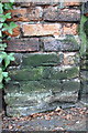
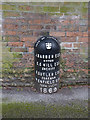
Benchmark on wall pier at Burnham House, Elm Bank
Ordnance Survey cut mark benchmark described on the Bench Mark Database at http://www.bench-marks.org.uk/bm47942
Image: © Roger Templeman
Taken: 1 Apr 2013
0.02 miles
2
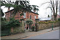
#6 Elm Bank, 'Burnham House'
There is an OS benchmark Image on the brick corner wall pier near the left hand side of the image
Image: © Roger Templeman
Taken: 1 Apr 2013
0.02 miles
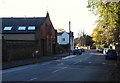
3
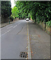
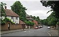
Up Elm Bank
Looking up the steep hill towards Mapperley Road.
Image: © John Sutton
Taken: 15 Jun 2014
0.04 miles
4
Nottingham, NG3 - Former Forest House
This single-storey wing is the former Out-Patients' Department of the former Nottingham Children's Hospital as seen from the Berkeley Ave entrance to the complex. The arched doorway on the right is a principal entrance into the former home of Sir Thomas Isaac Birkin, of the lace-making dynasty, who donated the house and grounds for conversion into a paediatric hospital in 1905 when he was created 1st Baronet of Ruddington Grange. In 1939 John Dane Player, of the tobacco company, funded the extensions on the left. The premises became the HQ of the Nottinghamshire Area Health Authority in the early 1980s and later the base of the Nottingham Health Authority. It is now owned and used by an Islamic Trust.
Image: © David Hallam-Jones
Taken: 3 Nov 2012
0.05 miles
5
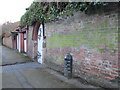
Boundary Marker, Redcliffe Road
In 1869 this was still the municipal boundary. The marker is one of a number erected in connection with Poor Law area boundaries. Listed Grade II. See http://www.geograph.org.uk/photo/3903439 for location.
Image: © Alan Murray-Rust
Taken: 18 Mar 2014
0.05 miles
6
Down Redcliffe Road
Looking down the hill towards Mansfield Road on a dull Sunday morning in mid June.
Image: © John Sutton
Taken: 15 Jun 2014
0.05 miles
7
Boundary Marker on Redcliffe Road
Redcliffe Road (then Red Lane) marked the northern boundary of Nottingham prior to boundary extensions in 1877.
Image: © Jonathan Thacker
Taken: 15 Jan 2016
0.06 miles
8
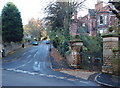
Nottingham, NG3 - Mapperley Park
Looking up Elm Bank from Redcliffe Road. Red Lane, as it was known until c.1870, was apparently "inaccessible during the winter months". Therefore, this link with Mapperley Road - if it existed in the 19th century - would have been impossible to ascend. The gates on the right open into the stable block forecourt of Claremont House, the large bay-windowed property.
Image: © David Hallam-Jones
Taken: 4 Nov 2012
0.06 miles
9
Nottingham, NG3 - Mapperley Park
Looking along Redcliffe Road in the direction of Mansfield Road (the A60) from Mapperley Road that lies behind the photographer. Red Lane, as it was known until c.1870, was apparently "inaccessible during the winter months". Heavy brick-laden carts descending from Mapperley's brickworks would no doubt have contributed to the damage to this unmade road. On the left is the former coach house of Claremont House situated on neighbouring Elm Bank. The coach house is now a separate property that has been converted into a private house known as "Claremont Stables".
Image: © David Hallam-Jones
Taken: 4 Nov 2012
0.06 miles
10
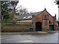
Claremont Stables, Redcliffe Road
Purpose-built stables and coach-house for a large house called Claremont.http://www.geograph.org.uk/photo/3210559
Image: © Alan Murray-Rust
Taken: 18 Mar 2014
0.06 miles