IMAGES TAKEN NEAR TO
Bangor Walk, NOTTINGHAM, NG3 4FS
Introduction
This page details the photographs taken nearby to Bangor Walk, NG3 4FS by members of the Geograph project.
The Geograph project started in 2005 with the aim of publishing, organising and preserving representative images for every square kilometre of Great Britain, Ireland and the Isle of Man.

There are currently over 7.5m images from over14,400 individuals and you can help contribute to the project by visiting https://www.geograph.org.uk
Image Map
Images are licensed for reuse under creativecommons.org/licenses/by-sa/2.0
Notes
- Clicking on the map will re-center to the selected point.
- The higher the marker number, the further away the image location is from the centre of the postcode.
Image Listing (239 Images Found)
Images are licensed for reuse under creativecommons.org/licenses/by-sa/2.0
Image
Details
Distance
1
A Bullseye winner in St Ann's
Though they would have won a speedboat not a small yacht.
For the reference see https://en.wikipedia.org/wiki/Bullseye_(UK_game_show)
Image: © David Lally
Taken: 29 Apr 2018
0.02 miles
2
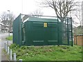
New substation
This compact substation is very recent. It does not appear on Streetview in May 2015.
Image: © Michael Dibb
Taken: 31 Mar 2017
0.03 miles
3
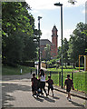
Going to school in St Ann's
Now Welbeck Walk, this was once Alfred Street, one of the main thoroughfares in St Ann's, whose slum terraces were demolished in the 1970s and replaced by low-density housing. In the background is Watson Fothergill's Woodborough Road Baptist Church, now the Pakistan Centre (see Image]).
Image: © John Sutton
Taken: 6 Jul 2015
0.03 miles
4
Play area
The play area is located off Alfred Road North.
Image: © Michael Dibb
Taken: 31 Mar 2017
0.05 miles
5
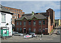
Alfred Street North: St Andrew's Parish Hall
The parish hall was built in 1914. Oldknow's Factory towers above it.
Image: © John Sutton
Taken: 6 Jul 2015
0.05 miles
6
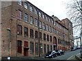
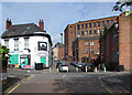
Oldknow's Factory [5]
This large lace making factory complex, known as Oldnow's Factory. The complex comprises two linked factory ranges and a separate ancillary building, currently partly vacant and partly in use as studios, offices, workshops and for textile manufacturing. This view is of the slightly older Egerton Street range, built circa 1850 for Lymbery, lace manufacturer.
The complex is listed, grade II, and there is much history and detail at: https://www.historicengland.org.uk/listing/the-list/list-entry/1391487
Image: © Michael Dibb
Taken: 31 Mar 2017
0.05 miles
7
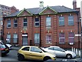
Former parish hall
Now occupied by Playworks.
Image: © Michael Dibb
Taken: 31 Mar 2017
0.05 miles
8
Oldknow's Factory [4]
This large lace making factory complex, known as Oldnow's Factory. The complex comprises two linked factory ranges and a separate ancillary building, currently partly vacant and partly in use as studios, offices, workshops and for textile manufacturing. This view is of the yard in the middle of the complex with the slightly more recent St Ann's Hill Road range to the left and the slightly older Egerton Street range in the centre and right.
The complex is listed, grade II, and there is much history and detail at: https://www.historicengland.org.uk/listing/the-list/list-entry/1391487
Image: © Michael Dibb
Taken: 31 Mar 2017
0.06 miles
9
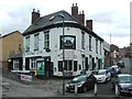
The Mechanics Arms, Nottingham
Also known as the Pride of Erin.
Image: © Chris Whippet
Taken: 28 Jul 2015
0.06 miles
10
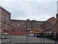
Up Alfred Street North
The Mechanics' Arms, an Irish pub, is on the left, the Grade II listed Oldknow's Factory ahead (see http://www.britishlistedbuildings.co.uk/en-492001-oldknows-factory-#.VZ_f5CiwHZY ) and St Andrew's Parish Hall on the right.
Image: © John Sutton
Taken: 6 Jul 2015
0.06 miles