IMAGES TAKEN NEAR TO
Aunsby, SLEAFORD, NG34 8TB
Introduction
This page details the photographs taken nearby to NG34 8TB by members of the Geograph project.
The Geograph project started in 2005 with the aim of publishing, organising and preserving representative images for every square kilometre of Great Britain, Ireland and the Isle of Man.

There are currently over 7.5m images from over14,400 individuals and you can help contribute to the project by visiting https://www.geograph.org.uk
Image Map
Images are licensed for reuse under creativecommons.org/licenses/by-sa/2.0
Notes
- Clicking on the map will re-center to the selected point.
- The higher the marker number, the further away the image location is from the centre of the postcode.
Image Listing (6 Images Found)
Images are licensed for reuse under creativecommons.org/licenses/by-sa/2.0
Image
Details
Distance
1
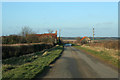
Forty Acre Farm
This farm is on the 45 metre contour. The road drops down comparatively steeply from the flat plateau above Dembleby and Aunsby towards Culverthorpe Road in Image The hills on the horizon are Willsford Warren.
Image: © Kate Jewell
Taken: 11 Feb 2007
0.01 miles
2
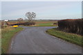
Junction of Aunsby Road and Green Road
Swarby is to the right.
Image: © J.Hannan-Briggs
Taken: 5 Jan 2014
0.14 miles
3
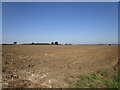
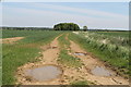
Ploughed field near Forty Acre Farm
Image: © Jonathan Thacker
Taken: 26 Aug 2019
0.14 miles
4
Road Linking Aunsby, Swarby and Culverthorpe
Image: © Pamela Farrington-Grantley
Taken: 22 Jan 2007
0.21 miles
5
Bridleway and farm track with drain
Image: © J.Hannan-Briggs
Taken: 26 May 2013
0.23 miles
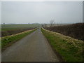
6
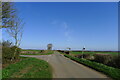
Aunsby Road at the junction with Aunsby Lane
In the south-west of the 'Southern Lincolnshire Edge' National Character Area; an: "Elevated arable escarpment [with] long, straight roads and tracks, often with wide verges." https://data.gov.uk/dataset/21104eeb-4a53-4e41-8ada-d2d442e416e0/national-character-areas-england
Image: © Tim Heaton
Taken: 30 Mar 2021
0.23 miles