IMAGES TAKEN NEAR TO
Brauncewell, SLEAFORD, NG34 8RQ
Introduction
This page details the photographs taken nearby to NG34 8RQ by members of the Geograph project.
The Geograph project started in 2005 with the aim of publishing, organising and preserving representative images for every square kilometre of Great Britain, Ireland and the Isle of Man.

There are currently over 7.5m images from over14,400 individuals and you can help contribute to the project by visiting https://www.geograph.org.uk
Image Map
Images are licensed for reuse under creativecommons.org/licenses/by-sa/2.0
Notes
- Clicking on the map will re-center to the selected point.
- The higher the marker number, the further away the image location is from the centre of the postcode.
Image Listing (14 Images Found)
Images are licensed for reuse under creativecommons.org/licenses/by-sa/2.0
Image
Details
Distance
3
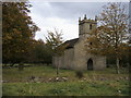
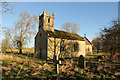
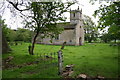
All Saints Church
All Saints Church Brauncewell closed since 1973
Image: © Shaun Ferguson
Taken: 12 Oct 2009
0.06 miles
4
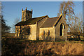
All Saints' church
The Domesday survey in 1086 says there was a church at Brauncewell, perhaps on this site, in the surrounding fields are the mounds & hollows of the site of the deserted medieval village of Brauncewell. This church has later medieval origins, of which only the font remains, the rest is mostly early 19th century. It was declared redundant in 1973 and is now in the capable care of the Lincolnshire Old Churches Trust.
Image: © Richard Croft
Taken: 16 Jan 2014
0.07 miles
6
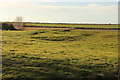
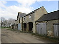
Brauncewell Home Close
Part of the remains of the deserted medieval village of Brauncewell south of All Saints' church, known in the 19th century as 'Home Close'. A group of buildings represented by substantial earthworks, including buried stone walls, standing up to 2m in height. Some of these buildings were still standing in the 19th century and are thought to have included a vicarage.
Image: © Richard Croft
Taken: 16 Jan 2014
0.08 miles
7
All Saints' church
The Domesday survey in 1086 says there was a church at Brauncewell, perhaps on this site, in the surrounding fields are the mounds & hollows of the site of the deserted medieval village of Brauncewell. This church has later medieval origins, of which only the font remains, the rest is mostly early 19th century. It was declared redundant in 1973 and is now in the capable care of the Lincolnshire Old Churches Trust.
Image: © Richard Croft
Taken: 16 Jan 2014
0.08 miles
8
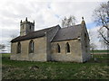
All Saints Brauncewell
Nave and tower early nineteenth century. Chancel a little later 1855. No longer in use. Interior gutted.
Image: © Jonathan Thacker
Taken: 27 Mar 2015
0.09 miles
9
All Saints' church, Brauncewell, Lincs.
The Domesday survey in 1086 says there was a church at Brauncewell, perhaps on this site, in the surrounding fields are the mounds & hollows of the site of the deserted medieval village of Brauncewell. This church has later medieval origins, of which only the font remains, the rest is mostly early 19th century. It was declared redundant in 1973 and is now in the capable care of the Lincolnshire Old Churches Trust.
Image: © Richard Croft
Taken: 8 May 2006
0.09 miles
10
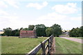
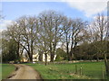
Old building at Brauncewell (3)
Looking north towards the houses. No-one seems to know what the building was used for. Adjacent to footpath as you enter Brauncewell from the north.
Image: © Chris
Taken: 24 Jul 2011
0.11 miles