IMAGES TAKEN NEAR TO
Church View, SLEAFORD, NG34 8HF
Introduction
This page details the photographs taken nearby to Church View, NG34 8HF by members of the Geograph project.
The Geograph project started in 2005 with the aim of publishing, organising and preserving representative images for every square kilometre of Great Britain, Ireland and the Isle of Man.

There are currently over 7.5m images from over14,400 individuals and you can help contribute to the project by visiting https://www.geograph.org.uk
Image Map
Images are licensed for reuse under creativecommons.org/licenses/by-sa/2.0
Notes
- Clicking on the map will re-center to the selected point.
- The higher the marker number, the further away the image location is from the centre of the postcode.
Image Listing (48 Images Found)
Images are licensed for reuse under creativecommons.org/licenses/by-sa/2.0
Image
Details
Distance
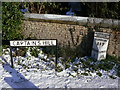
3
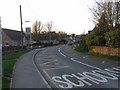
Lincoln Road to Captain's Hill
Looking downhill from beside the Duke of Wellington pub. The spire of St Andrew's Church Image is visible in the background.
Image: © Ian Paterson
Taken: 10 Apr 2012
0.06 miles
4
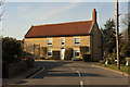
Hall Farmhouse
Grade II listed mid-18th century farmhouse on Captain's Hill in Leasingham
Image: © Richard Croft
Taken: 2 Apr 2015
0.07 miles
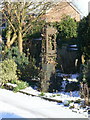
5
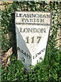
Milestone, Leasingham
Early 19th cast iron milestone on the main road through Leasingham. The English Heritage listing suggests that it has been moved from the opposite side of the road because Lincoln (to the north) is shown on the south face, and Sleaford vice versa. However, the normal practice on triangular milestones is for the facing side to show the place towards which the oncoming traveller is facing. The milestone is shown at this position on the 1905 1:2500 map, which certainly suggests that it is in its original location. Listed grade II.
Image: © Alan Murray-Rust
Taken: 20 Dec 2009
0.07 miles
7
Ancient petrol pump
At Hall Farm, standing alongside what would have been the entrance to the farmyard.
Image: © Alan Murray-Rust
Taken: 20 Dec 2009
0.08 miles
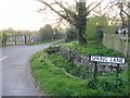
9
Sleaford 2
Old milepost on what would have been the A15 until bypassed at Leasingham, Lincolnshire. For overall view see http://www.geograph.org.uk/photo/2869043
Image: © Keith Evans
Taken: 24 Mar 2012
0.08 miles
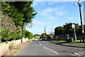
10
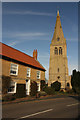
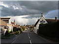
Captain's Hill
Hall Farmhouse http://www.geograph.org.uk/photo/4428194 and St.Andrew's Church tower & spire in Leasingham
Image: © Richard Croft
Taken: 2 Apr 2015
0.08 miles