IMAGES TAKEN NEAR TO
Eastgate, SLEAFORD, NG34 7ZX
Introduction
This page details the photographs taken nearby to Eastgate, NG34 7ZX by members of the Geograph project.
The Geograph project started in 2005 with the aim of publishing, organising and preserving representative images for every square kilometre of Great Britain, Ireland and the Isle of Man.

There are currently over 7.5m images from over14,400 individuals and you can help contribute to the project by visiting https://www.geograph.org.uk
Image Map
Images are licensed for reuse under creativecommons.org/licenses/by-sa/2.0
Notes
- Clicking on the map will re-center to the selected point.
- The higher the marker number, the further away the image location is from the centre of the postcode.
Image Listing (535 Images Found)
Images are licensed for reuse under creativecommons.org/licenses/by-sa/2.0
Image
Details
Distance
1
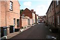
Cross Keys Yard
Yard off Eastgate in Sleaford
Image: © Richard Croft
Taken: 3 Sep 2008
0.02 miles
2
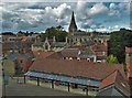
Rooftops of Sleaford
Seen from The National Centre for Craft and Design. Looking towards the parish church which is dedicated to St Denys.
Image: © Neil Theasby
Taken: 11 Sep 2017
0.03 miles
3
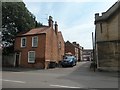
Cross Key Yard, Sleaford
Running south from East Gate, opposite the parish church. 'Cross Keys' usually indicates a dedication to St Peter, but the parish church is dedicated to St Denys.
Image: © Christine Johnstone
Taken: 14 Aug 2020
0.03 miles
4
Sleaford Navigation Weighing Office
Image: © Betty Longbottom
Taken: 7 Sep 2009
0.03 miles
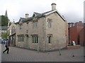
5
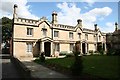
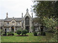
Carre's Hospital
Tudor Gothic almshouses built by Charles Kirk in 1830 to a design by H.E.Kendall. The Hospital was founded in 1636 by Lord of the Manor Thomas Carre to house twelve local men
Image: © Richard Croft
Taken: 3 Sep 2008
0.03 miles
6
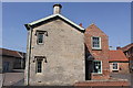
Navigation House, Navigation Yard, Carre Street
Grade II Listed this building is probably unique in being the only example of specially built Company Offices to exist on a rural waterway. It was finished in 1839 and consisted of an office for the Clerk with the weighing machine in it, a Committee Room for meetings and two upstairs rooms that were to provide accommodation for the Clerk. A small brick extension was later added at the back. After the Sleaford Navigation Company was wound up in 1878, Navigation House continued to be used as a dwelling until the 1950’s when the building gradually fell into disrepair. The building escaped demolition in the 1970s thanks to the Sleaford Navigation Society and with help from the Heritage Lottery and Sleaford Pride it opened as a visitor centre for the Sleaford Navigation in 2005.
Image: © Jo and Steve Turner
Taken: 25 Apr 2011
0.03 miles
7
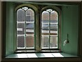
Wonky window in Navigation House, Sleaford
Navigation House - once connected with Sleaford's Navigation Canal - is now a museum which speaks of local history, especially in relation to industry and canal transport.
Image: © Neil Theasby
Taken: 11 Sep 2017
0.03 miles
8
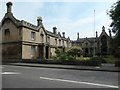
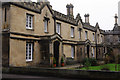
Carre's Almshouses, Sleaford
Also known as Carre's Hospital. Founded in 1636 to house and support 12 [later 18] local men. The east [left] wing was built in 1830, the south [right] wing in 1841-6.
Image: © Christine Johnstone
Taken: 14 Aug 2020
0.04 miles
9
Carre's Hospital
Almshouses dating from 1841-6. This is an extension to earlier building (out of the picture the left).
Image: © Jonathan Thacker
Taken: 20 Oct 2017
0.04 miles
10
Carre's Almshouses
The almshouse provision (a 'hospital') was founded by Sir Robert Carre, a major local landowner, in 1636 to house and support 12 poor local men. The present buildings are mid 19th century.
Image: © Stephen McKay
Taken: 13 Dec 2015
0.04 miles