IMAGES TAKEN NEAR TO
Carre Street, SLEAFORD, NG34 7ZD
Introduction
This page details the photographs taken nearby to Carre Street, NG34 7ZD by members of the Geograph project.
The Geograph project started in 2005 with the aim of publishing, organising and preserving representative images for every square kilometre of Great Britain, Ireland and the Isle of Man.

There are currently over 7.5m images from over14,400 individuals and you can help contribute to the project by visiting https://www.geograph.org.uk
Image Map
Images are licensed for reuse under creativecommons.org/licenses/by-sa/2.0
Notes
- Clicking on the map will re-center to the selected point.
- The higher the marker number, the further away the image location is from the centre of the postcode.
Image Listing (586 Images Found)
Images are licensed for reuse under creativecommons.org/licenses/by-sa/2.0
Image
Details
Distance
1
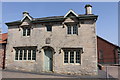
Navigation House, Navigation Yard, Carre Street
Grade II Listed this building is probably unique in being the only example of specially built Company Offices to exist on a rural waterway. It was finished in 1839 and consisted of an office for the Clerk with the weighing machine in it, a Committee Room for meetings and two upstairs rooms that were to provide accommodation for the Clerk. A small brick extension was later added at the back. After the Sleaford Navigation Company was wound up in 1878, Navigation House continued to be used as a dwelling until the 1950’s when the building gradually fell into disrepair. The building escaped demolition in the 1970s thanks to the Sleaford Navigation Society and with help from the Heritage Lottery and Sleaford Pride it opened as a visitor centre for the Sleaford Navigation in 2005.
Image: © Jo and Steve Turner
Taken: 25 Apr 2011
0.00 miles
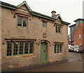
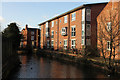
2

Navigation Wharf
Since Image was taken, the new flats have been built next to the Wharf, and the old gateway becomes a private gate.
Having stood true and upright for 211 years it is now on the skew.
Image: © Bob Harvey
Taken: 2 Oct 2012
0.01 miles
3
Carre Street Vicinity, Sleaford, Lincs.
The Sleaford Navigation Company’s decision to install a weighbridge and build an associated 'hut' coincided with a rise in its prosperity. Consequently, the company resolved to erect a building that befitted its status. Thus Navigation House was built in 1839, consisting of an office for the clerk with the weighing machine in it, a Committee Room for meetings and two upstairs living rooms for the clerk. After the company was wound up in 1878 the house continued as a dwelling until the 1950s when it gradually fell into disrepair. There was an attempt in the early 1970s to demolish it and this led to the formation of the Sleaford Navigation Society whose aim was to preserve the house. It was saved from demolition although no funds were available for the necessary restoration work. Shortly after 1999, when the building was in an even worse state of repair, money was finally secured to renovate it and in 2005 it was reopened to the public as a Visitor Centre with particular emphasis on the Sleaford Navigation. Part of The National Centre for Craft and Design - also on Navigation Wharf - is also visible.
Image: © David Hallam-Jones
Taken: 29 Nov 2014
0.01 miles
4
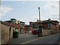
Entrance to Navigation Yard, Sleaford
Image: © Jonathan Thacker
Taken: 17 Aug 2024
0.01 miles
7
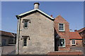
Navigation House, Navigation Yard, Carre Street
Grade II Listed this building is probably unique in being the only example of specially built Company Offices to exist on a rural waterway. It was finished in 1839 and consisted of an office for the Clerk with the weighing machine in it, a Committee Room for meetings and two upstairs rooms that were to provide accommodation for the Clerk. A small brick extension was later added at the back. After the Sleaford Navigation Company was wound up in 1878, Navigation House continued to be used as a dwelling until the 1950’s when the building gradually fell into disrepair. The building escaped demolition in the 1970s thanks to the Sleaford Navigation Society and with help from the Heritage Lottery and Sleaford Pride it opened as a visitor centre for the Sleaford Navigation in 2005.
Image: © Jo and Steve Turner
Taken: 25 Apr 2011
0.01 miles
8
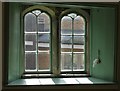
Wonky window in Navigation House, Sleaford
Navigation House - once connected with Sleaford's Navigation Canal - is now a museum which speaks of local history, especially in relation to industry and canal transport.
Image: © Neil Theasby
Taken: 11 Sep 2017
0.01 miles
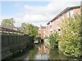
9
Arthur's Court
Apartments by the River Slea at Navigation Wharf
Image: © Richard Croft
Taken: 23 Jan 2014
0.01 miles
10
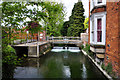
Weir on the River Slea - Sleaford
It is at this point that the Slea and Nine Foot Rivers meet at the Navigation.
Image: © Mick Lobb
Taken: 17 May 2010
0.01 miles