IMAGES TAKEN NEAR TO
West Banks, SLEAFORD, NG34 7PZ
Introduction
This page details the photographs taken nearby to West Banks, NG34 7PZ by members of the Geograph project.
The Geograph project started in 2005 with the aim of publishing, organising and preserving representative images for every square kilometre of Great Britain, Ireland and the Isle of Man.

There are currently over 7.5m images from over14,400 individuals and you can help contribute to the project by visiting https://www.geograph.org.uk
Image Map
Images are licensed for reuse under creativecommons.org/licenses/by-sa/2.0
Notes
- Clicking on the map will re-center to the selected point.
- The higher the marker number, the further away the image location is from the centre of the postcode.
Image Listing (540 Images Found)
Images are licensed for reuse under creativecommons.org/licenses/by-sa/2.0
Image
Details
Distance
2
How to Make Music....
Simple. Buy a packet of guitar seeds, grow under glass at minimum 20 degrees and prick out into a large pot filled with well-rotted compost until it's 6 inches tall. Plant on in its permanent position in well-drained soil amongst other plants, ideally with a gravel mulch. As soon as the first fruits start to appear (in around 20 years) cut back all but the best one and eventually you will be rewarded with a fine specimen.
Unfortunately for this gardener, he didn't do enough "Bert" (Weedon) and as a result an infestation of minimitis occurred and is now sadly peppered with the wee beasties' characteristic flight holes.
Image: © Ian Paterson
Taken: 18 May 2020
0.04 miles
3
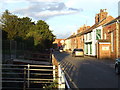
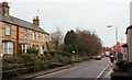
West Banks, Sleaford
West Banks, with the River Slea running alongside in a channel.
Image: © Malc McDonald
Taken: 11 Sep 2010
0.05 miles
4
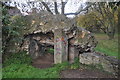
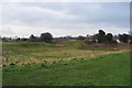
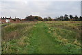
Sleaford Castle
All that remains of the castle, once an impressive stone structure.
http://www.sleaford.gov.uk/castle.html
Image: © Ashley Dace
Taken: 21 Nov 2010
0.06 miles
5
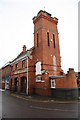
The Old Fire Station
The former Fire Station on Watergate in Sleaford
Image: © Richard Croft
Taken: 6 Feb 2009
0.06 miles
6
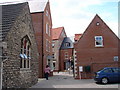
West Banks, Sleaford, Lincs.
Pedestrian bridges over River Slea to houses on the north side of West Banks (road name). Water Gate (road name) and the town centre lie ahead.
Image: © David Hallam-Jones
Taken: 29 Nov 2014
0.06 miles
7
Sleaford Castle
All that remains of the castle, once an impressive stone structure.
http://www.sleaford.gov.uk/castle.html
Image: © Ashley Dace
Taken: 21 Nov 2010
0.07 miles
8
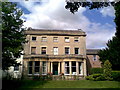
Westgate House, Westgate
Currently home to mri Software LLC, formerly known as Qube Global Software, formerly known as Estate Computer Systems https://www.mrisoftware.com/uk/.
Previously home of the Water Board.
Image: © Ian Paterson
Taken: 30 Aug 2007
0.07 miles
9
New Shops and Flats
Forming a new link between Southgate and Westgate.
Image: © Ian Paterson
Taken: 1 Aug 2007
0.07 miles
10
Sleaford Castle - Gatehouse
Noting but earthworks now but this was the gatehouse.
http://www.sleaford.gov.uk/castle.html
Image: © Ashley Dace
Taken: 21 Nov 2010
0.07 miles