IMAGES TAKEN NEAR TO
Northgate, SLEAFORD, NG34 7DB
Introduction
This page details the photographs taken nearby to Northgate, NG34 7DB by members of the Geograph project.
The Geograph project started in 2005 with the aim of publishing, organising and preserving representative images for every square kilometre of Great Britain, Ireland and the Isle of Man.

There are currently over 7.5m images from over14,400 individuals and you can help contribute to the project by visiting https://www.geograph.org.uk
Image Map
Images are licensed for reuse under creativecommons.org/licenses/by-sa/2.0
Notes
- Clicking on the map will re-center to the selected point.
- The higher the marker number, the further away the image location is from the centre of the postcode.
Image Listing (362 Images Found)
Images are licensed for reuse under creativecommons.org/licenses/by-sa/2.0
Image
Details
Distance
1
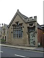
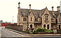
Carre's Charity, Northgate
Founded in 1636 and rebuilt in 1857 by Charles Kirk. https://www.britishlistedbuildings.co.uk/101062129-carres-charity-sleaford#.WepyTYhrzVI
Image: © Jonathan Thacker
Taken: 20 Oct 2017
0.01 miles
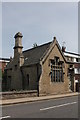
2
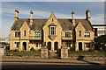
Carre's Hospital
Grade II listed almshouses on Northgate founded by Robert Carre in 1636, rebuilt by Charles Kirk in 1857
Image: © Richard Croft
Taken: 2 Apr 2015
0.01 miles
3
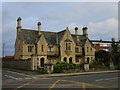
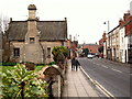
North Gate, Sleaford, Lincs.
Two buildings on the east side of Northgate in the Galley Hill area, with the B1518 beginning to descend towards the town centre on the right of the picture. The side road is Church Lane, which very quickly curves to form an arc round the back of these buildings and rejoins North Gate half a mile further on towards the town centre. The larger building constitutes the Northgate Almshouses built in 1857 as an addition to the Carre’s Hospital Almshouses in Eastgate. The smaller building - part of the same development - bears a stone inscription declaring it to be a "Savings Bank".
Image: © David Hallam-Jones
Taken: 29 Nov 2014
0.01 miles
4
North Gate, Sleaford, Lincs.
The building on left sits in the south-west corner of a site on the east side of North Gate that is occupied - for the most part - by the Northgate Almshouses. These were built in 1857 as an addition to the Carre’s Hospital Almshouses in Eastgate. However, the converted building ahead, with the Carre family crest on its chimney stack, bears a stone inscription on its road-facing elevation declaring it to be a "Savings Bank". It is now a residential property. The road here is the B1518, as it begins its descent towards the town centre.
Image: © David Hallam-Jones
Taken: 29 Nov 2014
0.01 miles
5
Corner of Church Lane - Sleaford
Carre's Grammar School is located here between Church Lane and Mill Field Terrace.
Image: © Mick Lobb
Taken: 17 May 2010
0.02 miles
6
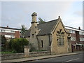
Former Savings Bank
Designed by Charles Kirk 1857 https://www.britishlistedbuildings.co.uk/101062129-carres-charity-sleaford#.Wez5rohrzVI
Image: © Jonathan Thacker
Taken: 20 Oct 2017
0.02 miles
7
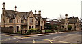
North Gate/Church Lane, Sleaford, Lincs.
Sleaford's "Community Fire Station" on Church Lane can be seen here near the north-east corner of the site occupied by the Northgate Almshouses. This almshouse building was constructed in 1857 as an addition to the Carre’s Hospital Almshouses in Eastgate. Church Lane passes the front of the fire station and forms a 'c' shaped arc around the back of the almshouses before it rejoins North Gate half a mile further on towards the town centre. The principal road at this junction is the B1518.
Image: © David Hallam-Jones
Taken: 29 Nov 2014
0.02 miles
8
Old Savings Bank, 38a North Gate, Sleaford
Grade II Listed The Old Savings Bank was part of the almshouses development by Charles Kirk as an extension to the Carre's Hospital in East Gate in 1857. Pevsner mistakenly lists the North Gate site as the site of the original 17th century foundation.
Image: © Jo and Steve Turner
Taken: 12 Jul 2013
0.02 miles
9

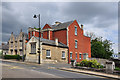
Church Lane Fire Station - Sleaford
Differing somewhat from the old one!
Image: © Mick Lobb
Taken: 27 Dec 2009
0.02 miles