IMAGES TAKEN NEAR TO
Sempringham Fen, SLEAFORD, NG34 0NH
Introduction
This page details the photographs taken nearby to NG34 0NH by members of the Geograph project.
The Geograph project started in 2005 with the aim of publishing, organising and preserving representative images for every square kilometre of Great Britain, Ireland and the Isle of Man.

There are currently over 7.5m images from over14,400 individuals and you can help contribute to the project by visiting https://www.geograph.org.uk
Image Map
Images are licensed for reuse under creativecommons.org/licenses/by-sa/2.0
Notes
- Clicking on the map will re-center to the selected point.
- The higher the marker number, the further away the image location is from the centre of the postcode.
Image Listing (12 Images Found)
Images are licensed for reuse under creativecommons.org/licenses/by-sa/2.0
Image
Details
Distance
1
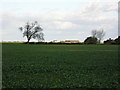
View to Neslam Farm
This view is from the edge of a field off Neslam Road looking along a ditch across Neslam Fen to Neslam Farm in the distance. Isolated farms with their associated barns and a few trees are all that tend to break up the skyline on these flat lands.
Image: © Marathon
Taken: 28 Jul 2014
0.04 miles
2
Neslam Farm from Neslam Road
This is a typical fenland scene with a flat landscape, large hedgeless fields, often isolated trees and lonely farms. The nearest farms to Neslam Farm out on Neslam Fen are at least half a mile away.
Image: © Marathon
Taken: 4 Nov 2011
0.05 miles
4
Neslam Farm, Neslam Fen
Complete with 500m airstrip and potentially the site for a six turbine wind farm should a successful planning application grant permission.
Image: © Roger Callow
Taken: 13 Nov 2006
0.08 miles
5
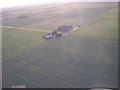
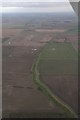
Neslam Farm and air strip, Neslam Fen
Aerial photo showing airstrip extending to the left from the farm buildings. Proposed site of six 125m high wind turbines.
Image: © Roger Callow
Taken: 14 Nov 2006
0.08 miles
6
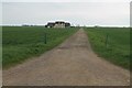
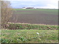
Track to Neslam Farm, from Neslam Road
Image: © J.Hannan-Briggs
Taken: 8 Apr 2012
0.11 miles
7
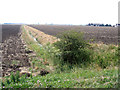
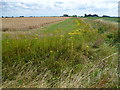
Farmland, Neslam Fen, Pointon, Lincs
– view SSW from Neslam Road.
Image: © Rodney Burton
Taken: 5 Aug 2006
0.15 miles
8
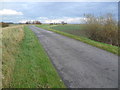
Neslam Road
Each of the villages between Bourne and Heckington, a distance of some 15 miles, almost without exception has a road leading out onto the fen named after its village and terminating at the South Forty Foot Drain. Neslam Road which runs eastwards from the B1177 between Billingborough and Pointon is an exception as it crosses the South Forty Foot Drain at Neslam Bridge. Unlike some of the other roads which cross the South Forty Foot Drain, it is a fairly quiet, narrow and bumpy road. This is a typical fenland scene with a flat landscape, large hedgeless fields, often isolated trees and lonely farms.
Image: © Marathon
Taken: 4 Nov 2011
0.20 miles
9

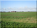
View across Neslam Fen
This view is from the edge of a field off Neslam Road looking across Neslam Fen to Neslam Road in the distance.
Image: © Marathon
Taken: 28 Jul 2014
0.21 miles