IMAGES TAKEN NEAR TO
High Street, SLEAFORD, NG34 0LY
Introduction
This page details the photographs taken nearby to High Street, NG34 0LY by members of the Geograph project.
The Geograph project started in 2005 with the aim of publishing, organising and preserving representative images for every square kilometre of Great Britain, Ireland and the Isle of Man.

There are currently over 7.5m images from over14,400 individuals and you can help contribute to the project by visiting https://www.geograph.org.uk
Image Map
Images are licensed for reuse under creativecommons.org/licenses/by-sa/2.0
Notes
- Clicking on the map will re-center to the selected point.
- The higher the marker number, the further away the image location is from the centre of the postcode.
Image Listing (11 Images Found)
Images are licensed for reuse under creativecommons.org/licenses/by-sa/2.0
Image
Details
Distance
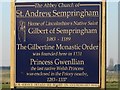
1
Wheatfields, Sempringham, Lincs
– view along the lane from Sempringham Priory towards the B1177 Pointon Road.
Image: © Rodney Burton
Taken: 5 Aug 2006
0.16 miles
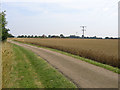
2
The line of the former Bourne & Sleaford Railway
The Bourne & Sleaford Railway arose out of a proposal by the Great Eastern Railway to open a line from Cambridge to York, via Essendine, Bourne, Sleaford and Lincoln. Parliament though refused to authorise it. The Great Northern Railway had already proposed the Bourne to Sleaford section and opened this in 1872.
The line closed to passengers in 1930, although the section from Bourne through Rippingale to Billingborough remained open for goods until 1964. This section of line had therefore been closed 50 years when I photographed it. The line followed the left hand side of this field on its way to Rippingale - see http://www.geograph.org.uk/photo/3966050
Image: © Marathon
Taken: 28 Jul 2014
0.18 miles
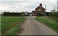
3
Church farm
View along the valley of the Marse Dyke to Church Farm. When it crosses the road the stream becomes the Billingborough Lode.
Image: © Bob Harvey
Taken: 27 May 2013
0.20 miles
5
The road to Sempringham, near Bourne, Lincolnshire
The best route to Sempringham church is along the A15 and then fork off on the B1177 north of Bourne, taking the second left turn at Pointon village and then look out for this blue sign alongside a farm track on the left hand side. You will then face almost a mile of uneven cart track but a glimpse of the pinnacled tower of the Norman church is always with you behind trees on the horizon, a lonely landmark on a hillock among cultivated fields, and soon the winding road will bring you to its door. See also Image
Image: © Rex Needle
Taken: 11 Oct 2009
0.20 miles
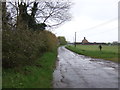
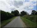
6
Track from St Andrew's church joins Pointon Road
Image: © J.Hannan-Briggs
Taken: 8 Apr 2012
0.21 miles
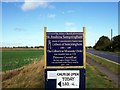
8
Birthplace of the Gilbertine Monastic Order
Signpost to a number of religious and historic sights. Not mentioned is St Gilbert's Well, which can be seen in Image
For information on Saint Gilbert, see http://www.catholic-forum.com/saints/saintg30.htm
Image: © Ian Paterson
Taken: 17 Feb 2008
0.22 miles
9
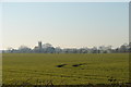
Tracks in the Fields
The Abbey Church of St Andrew can be seen in the distance.
Image: © Ian Paterson
Taken: 17 Feb 2008
0.23 miles
10
Neslam Road
The house on the right was a gatehouse on the former railway from Bourne to Sleaford.
Image: © Jonathan Thacker
Taken: 2 Jul 2019
0.23 miles