IMAGES TAKEN NEAR TO
Bridge End Causeway, SLEAFORD, NG34 0JU
Introduction
This page details the photographs taken nearby to Bridge End Causeway, NG34 0JU by members of the Geograph project.
The Geograph project started in 2005 with the aim of publishing, organising and preserving representative images for every square kilometre of Great Britain, Ireland and the Isle of Man.

There are currently over 7.5m images from over14,400 individuals and you can help contribute to the project by visiting https://www.geograph.org.uk
Image Map
Images are licensed for reuse under creativecommons.org/licenses/by-sa/2.0
Notes
- Clicking on the map will re-center to the selected point.
- The higher the marker number, the further away the image location is from the centre of the postcode.
Image Listing (20 Images Found)
Images are licensed for reuse under creativecommons.org/licenses/by-sa/2.0
Image
Details
Distance
1
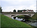
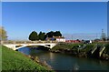
Donington High Bridge, Donington, Lincs
constructed in 1926 to carry the Bridge End Causeway across the South Forty Foot Drain; the Sloop Inn is in the background.
Image: © Rodney Burton
Taken: 26 Aug 2006
0.02 miles
2
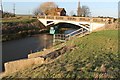
Donington High Bridge and Gauging Station
The A52 runs on this bridge over the South Forty Foot Drain
Image: © J.Hannan-Briggs
Taken: 2 Jan 2012
0.02 miles
3
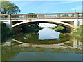
Donington High Bridge
On the south side of the road bridge, I am technically in un-navigable water at this point, but guess what - I turned back shortly afterwards for fear of running aground.
Here's a much cooler aspect Image
Image: © Ian Paterson
Taken: 9 May 2024
0.02 miles
4
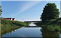
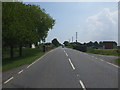
Approaching the A52 at Donington High Bridge
The barely visible signpost to the left of the telegraph pole has a warning exclamation eark sign with a notice below reading 'End of Navigation' despite it looking perfectly navigable from here.
Better safe than sorry though.
Image: © Ian Paterson
Taken: 9 May 2024
0.02 miles
5
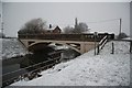
Donington High Bridge
The bridge was built in 1926 to replace a red brick hump-back (i.e. 'high') bridge, and carries the A52 over the South Forty Foot Drain. The white building on the right is the former Sloop Inn which, in the 19th century, used to serve barges carrying goods along the Drain https://sites.google.com/view/doningtonillustrated/pubs-inns/sloop
Image: © Tim Heaton
Taken: 20 Jan 2023
0.03 miles
7
Donington High Bridge
Erected jointly by the Holland & Kesteven County Councils and Black Sluice Drainage Commissioners 1926
Image: © Richard Croft
Taken: 14 Jan 2010
0.04 miles
8
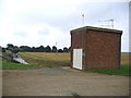
Mallard Hurn pumping station, Donington, Lincs
This Black Sluice Internal Drainage Board pumping station, constructed in 1967, drains a catchment of 365 ha and can move 566 litres/sec into the South Forty Foot Drain.
Image: © Rodney Burton
Taken: 26 Aug 2006
0.05 miles
9
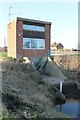
Mallard Hurn Pumping Station
Mallard Hurn pumping station, Donington, Lincs. This Black Sluice Internal Drainage Board pumping station, constructed in 1967, drains a catchment of 365 ha and can move 566 litres/sec into the South Forty Foot Drain.
Image: © J.Hannan-Briggs
Taken: 2 Jan 2012
0.05 miles
10
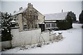
The Sloop Inn
Waterside and roadside hostelry, closed for about 18 months and for sale
Image: © Richard Croft
Taken: 14 Jan 2010
0.06 miles