IMAGES TAKEN NEAR TO
Bridge End, SLEAFORD, NG34 0JG
Introduction
This page details the photographs taken nearby to NG34 0JG by members of the Geograph project.
The Geograph project started in 2005 with the aim of publishing, organising and preserving representative images for every square kilometre of Great Britain, Ireland and the Isle of Man.

There are currently over 7.5m images from over14,400 individuals and you can help contribute to the project by visiting https://www.geograph.org.uk
Image Map
Images are licensed for reuse under creativecommons.org/licenses/by-sa/2.0
Notes
- Clicking on the map will re-center to the selected point.
- The higher the marker number, the further away the image location is from the centre of the postcode.
Image Listing (11 Images Found)
Images are licensed for reuse under creativecommons.org/licenses/by-sa/2.0
Image
Details
Distance
1
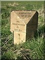
Old Milestone, on the B1177, Donington Road, Bridge End, opposite Priory Farm
Located on the West side of road, on the verge. Cast iron post, Billingboro iron casting design, erected by Donington to Hacconbury Field, SE District turnpike trust, 19th century.
Inscription reads: // TO / DONINGTON / 4 / MILES //TO / BILLINGBORO / 2½ / MILES //HORBLING / PARISH //.
Grade II listed by Historic England. see https://historicengland.org.uk/listing/the-list/list-entry/1317550
Milestone Society National ID: LI_BIDN02
Image: © Milestone Society
Taken: Unknown
0.01 miles
2
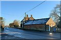
Priory Farmhouse, Holland Road, Bridge End
The western end of the Bridge End Causeway.
This farmhouse is on the site of the former Gilbertine priory of St Saviour, founded on or before 1199, whose canons were charged with the upkeep of the causeway. The farmhouse, with elements dating from the 12th century, was built using material from the derelict abbey https://www.british-history.ac.uk/vch/lincs/vol2/pp198-199 https://historicengland.org.uk/listing/the-list/list-entry/1062718?section=official-list-entry
Image: © Tim Heaton
Taken: 24 Jan 2023
0.02 miles
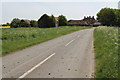
4
Bridge End
The Hamlet of Bridge End, eastern approach
Image: © Donnylad
Taken: 27 Mar 2007
0.05 miles
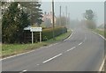
5
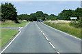
Mud on Holland Road towards the B1177
A passing tractor perhaps?
Image: © J.Hannan-Briggs
Taken: 26 May 2013
0.06 miles
6
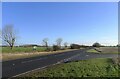
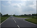
The A52 passing the Holland Road junction near Bridge End
A relatively new section of the main road. The original route followed Holland Road, to the right, past the hamlet of Bridge End.
Image: © Tim Heaton
Taken: 20 Jan 2023
0.08 miles
7
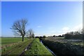
The Cross Britain Way following Swatton Eau near Bridge end
The Way follows the Swatton Eau drain for two miles towards Donington. The building on the distant right is Priory Farm, at Bridge End, on the site of the Gilbertine priory of St Saviour https://heritage-explorer.lincolnshire.gov.uk/Monument/MLI32832
Image: © Tim Heaton
Taken: 20 Jan 2023
0.08 miles
8
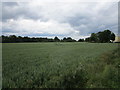
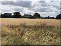
Wheat field at Bridge End
The trees belong to a small park surrounding Priory Farm.
Image: © Jonathan Thacker
Taken: 15 Jun 2019
0.12 miles