IMAGES TAKEN NEAR TO
Station Road, SLEAFORD, NG34 0AB
Introduction
This page details the photographs taken nearby to Station Road, NG34 0AB by members of the Geograph project.
The Geograph project started in 2005 with the aim of publishing, organising and preserving representative images for every square kilometre of Great Britain, Ireland and the Isle of Man.

There are currently over 7.5m images from over14,400 individuals and you can help contribute to the project by visiting https://www.geograph.org.uk
Image Map
Images are licensed for reuse under creativecommons.org/licenses/by-sa/2.0
Notes
- Clicking on the map will re-center to the selected point.
- The higher the marker number, the further away the image location is from the centre of the postcode.
Image Listing (21 Images Found)
Images are licensed for reuse under creativecommons.org/licenses/by-sa/2.0
Image
Details
Distance

2
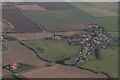
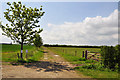
Hall Close, moated site at Scredington: aerial 2020
There were 5 moated sites at Scredington, one of which is Hall Close, a large medieval homestead surrounded by deserted tofts and crofts: https://ancientmonuments.uk/116742-hall-close-moated-manorial-complex-scredington#.XnjReXLgqUk
Two of the others are/were:
Hambleton Moat, destroyed in 1959: https://www.lincstothepast.com/Hambleton-Moat--Scredington/230117.record?pt=S ;
Thorny Close, at Northbeck (off shot top left): http://www.roffe.co.uk/earthworks/moats/scredington.htm
Image: © Chris
Taken: 22 Mar 2020
0.09 miles
3
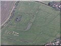
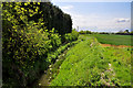
Hall Close moated site, Scredington: aerial 2022
Moated enclosure now in pasture, the moat mainly drained. Originally the principal moat in a village with five. The others have been excavated and/or destroyed. Surrounding the moat in the remainder of Hall Close are the platforms and enclosures of the original village settlement.
There were several important families in the village during the Middle Ages. The most prominent, the Pylets, occupied Hall Close from the late 12th to the mid 15th century.
The earthworks include the remains of fish ponds and a boundary ditch which would have enclosed the whole manorial complex.
See: https://www.heritagegateway.org.uk/Gateway/Results_Single.aspx?uid=MLI60728&resourceID=1006
Image: © Simon Tomson
Taken: 23 Jan 2022
0.10 miles
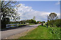
6
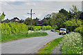
Station Road - Scredington
A vehicle has broken down on leaving the village and the AA is in attendance just past the bridge over North Beck.
Image: © Mick Lobb
Taken: 17 May 2010
0.13 miles
9
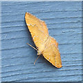
Moth
Bright Wave, Idaea ochrata.
Open to correction
Image: © Adrian S Pye
Taken: 16 Jun 2020
0.13 miles