IMAGES TAKEN NEAR TO
Hendon Rise, NOTTINGHAM, NG3 3AN
Introduction
This page details the photographs taken nearby to Hendon Rise, NG3 3AN by members of the Geograph project.
The Geograph project started in 2005 with the aim of publishing, organising and preserving representative images for every square kilometre of Great Britain, Ireland and the Isle of Man.

There are currently over 7.5m images from over14,400 individuals and you can help contribute to the project by visiting https://www.geograph.org.uk
Image Map
Images are licensed for reuse under creativecommons.org/licenses/by-sa/2.0
Notes
- Clicking on the map will re-center to the selected point.
- The higher the marker number, the further away the image location is from the centre of the postcode.
Image Listing (18 Images Found)
Images are licensed for reuse under creativecommons.org/licenses/by-sa/2.0
Image
Details
Distance
1
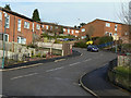
Brewsters Road
This was one of the last pieces of wholesale development in St Ann's, but it replaced allotment gardens rather than existing housing.
Image: © Alan Murray-Rust
Taken: 8 Mar 2009
0.05 miles
2
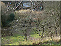
St Ann's Community Orchard
Developed on unused allotments in 2001, it provides oppotunities for education and community involvement.
In 2008 it won an award for Best Community Project as part of Nottingham in Bloom.
It even has its own spot on the St Ann's Allotments website http://www.staa-allotments.org.uk/orchard/index.htm
Image: © Alan Murray-Rust
Taken: 8 Mar 2009
0.15 miles
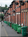
3

Bins, Ransom Road
Some of the bins have the instruction that they must be removed from the pavement after collection, but for these premises there is no alternative!
A different take on https://www.geograph.org.uk/photo/4033887 .
Image: © Alan Murray-Rust
Taken: 27 Nov 2022
0.16 miles
4
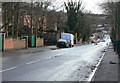
Ransom Road
Looking down towards St Ann's
Image: © Alan Murray-Rust
Taken: 8 Mar 2009
0.18 miles
5
Ransom Road: wheelie bins and satellite dishes
A typical Nottingham terrace, at the St Ann's Well Road end of Ransom Road.
Image: © John Sutton
Taken: 15 Jun 2014
0.20 miles
6
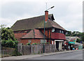
Ransom Road: The Canon Lewis Memorial Hall
According to the Draft List of Local Heritage Assets of the City of Nottingham, this building, designed in 1907 by Calvert & Gleave, is "plainer [and] less florid than the architects' drawing". It was owned by the 6th Nottingham Company of the Boys' Brigade from 1964-98. For details and the architects' drawing, see http://stannswellroad.weebly.com/the-boys-brigade.html .
Image: © John Sutton
Taken: 15 Jun 2014
0.20 miles
7
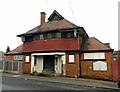
Canon Lewis Memorial Hall, Ransom Road
Built as a church hall in Arts and Crafts style in 1907, it has been disused since 1998. Some external refurbishment work appears to have been carried out around 2008, but it clearly continues to deteriorate.
Image: © Alan Murray-Rust
Taken: 27 Nov 2022
0.20 miles
8
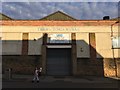
The V ctoria Works
The Wells Road, St Ann's
Image: © David Lally
Taken: 12 Aug 2017
0.21 miles
9
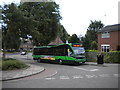
Kildare Road terminus
Once used by trolleybuses, the turning circle off The Wells Road at the foot of Kildare Road is now used by buses that terminate in St Ann's. The bus is about to operate the 41, which is the direct route to Nottingham city centre via St Ann's Well Road.
Image: © Richard Vince
Taken: 29 Jul 2010
0.21 miles
10
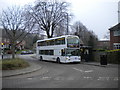
Double decker in Kildare Road turning circle, St Ann's
Nottingham City Transport operated a Boxing Day bus service on some of its ordinary city routes in 2013, the first such a service had been run for many years. NCT normally uses midibuses on route 41, which terminates here; however, presumably in case loadings were very high on the limited service operated, on Boxing Day a double decker, one of NCT's large fleet of Scania/East Lancs OmniDekkas, was used.
Image: © Richard Vince
Taken: 26 Dec 2013
0.21 miles