IMAGES TAKEN NEAR TO
Easton, GRANTHAM, NG33 5AS
Introduction
This page details the photographs taken nearby to NG33 5AS by members of the Geograph project.
The Geograph project started in 2005 with the aim of publishing, organising and preserving representative images for every square kilometre of Great Britain, Ireland and the Isle of Man.

There are currently over 7.5m images from over14,400 individuals and you can help contribute to the project by visiting https://www.geograph.org.uk
Image Map
Images are licensed for reuse under creativecommons.org/licenses/by-sa/2.0
Notes
- Clicking on the map will re-center to the selected point.
- The higher the marker number, the further away the image location is from the centre of the postcode.
Image Listing (11 Images Found)
Images are licensed for reuse under creativecommons.org/licenses/by-sa/2.0
Image
Details
Distance
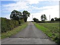
1
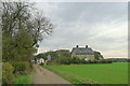
Approaching Ridd's Farm
The OS map shows the house on the right sitting next to the old route of the Roman road Ermine Street.
Image: © Tim Heaton
Taken: 1 Nov 2017
0.01 miles
3
Old railway embankment
This old line runs next to the B6403 just after leaving the A1 south of Grantham.
Image: © Terry Butcher
Taken: 14 Feb 2006
0.15 miles
4
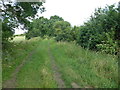
Route of dismantled railway near Ridd's Farm, Colsterworth
Image: © Richard Humphrey
Taken: 12 Jul 2015
0.15 miles
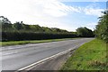
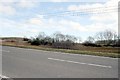
5
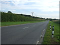
B6403 High Dike
The A1 also cuts through the corner of this square.
Image: © J.Hannan-Briggs
Taken: 14 Jul 2013
0.20 miles
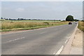
7
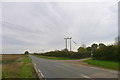
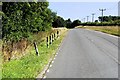
Entrance to Ridd's Farm from the B6403
The verges on the main road form the Colsterworth Bank Roadside Nature Reserve
Image: © Tim Heaton
Taken: 1 Nov 2017
0.22 miles