IMAGES TAKEN NEAR TO
Normanton, GRANTHAM, NG32 3BN
Introduction
This page details the photographs taken nearby to NG32 3BN by members of the Geograph project.
The Geograph project started in 2005 with the aim of publishing, organising and preserving representative images for every square kilometre of Great Britain, Ireland and the Isle of Man.

There are currently over 7.5m images from over14,400 individuals and you can help contribute to the project by visiting https://www.geograph.org.uk
Image Map
Images are licensed for reuse under creativecommons.org/licenses/by-sa/2.0
Notes
- Clicking on the map will re-center to the selected point.
- The higher the marker number, the further away the image location is from the centre of the postcode.
Image Listing (5 Images Found)
Images are licensed for reuse under creativecommons.org/licenses/by-sa/2.0
Image
Details
Distance
1
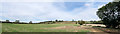
Normanton Hill
The house is far more prominent when you leave the village, on top of what is known locally as the Cliff - the Lincolnshire Escarpment. But the road is rather dangerous and I wanted somewhere safe to stand, so the house appears shaded by the tree.
The OS map labels a "sheep wash" on the hill, and the irregular ground on the scarp slope fascinates me - I hae no idea what it is. A rather closed look is shown in Image
Image: © Bob Harvey
Taken: 14 Sep 2019
0.04 miles
2
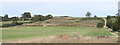
Excavation on the cliff edge
A closer look at the feature mentioned in Image
Image: © Bob Harvey
Taken: 14 Sep 2019
0.06 miles
3

Repeater tower
P
Originally part of the post office microwave system of the 1970s, this is now home to a series of cellphone antennae
Image: © Bob Harvey
Taken: 14 Sep 2019
0.18 miles
4
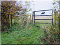
Horsey gate
A delightful gate by the side of the Viking Way cheers up a dull day.
Image: © Andy Stephenson
Taken: 3 Nov 2015
0.19 miles
5
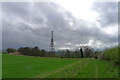
The Viking Way approaching the top of Normanton Hill
The mast of the Post Office Repeater Station is sited slightly down the scarp slope of the 'Lincoln Cliff'
Image: © Tim Heaton
Taken: 7 Apr 2014
0.20 miles