IMAGES TAKEN NEAR TO
Main Street, GRANTHAM, NG32 1SE
Introduction
This page details the photographs taken nearby to Main Street, NG32 1SE by members of the Geograph project.
The Geograph project started in 2005 with the aim of publishing, organising and preserving representative images for every square kilometre of Great Britain, Ireland and the Isle of Man.

There are currently over 7.5m images from over14,400 individuals and you can help contribute to the project by visiting https://www.geograph.org.uk
Image Map
Images are licensed for reuse under creativecommons.org/licenses/by-sa/2.0
Notes
- Clicking on the map will re-center to the selected point.
- The higher the marker number, the further away the image location is from the centre of the postcode.
Image Listing (214 Images Found)
Images are licensed for reuse under creativecommons.org/licenses/by-sa/2.0
Image
Details
Distance
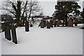
2
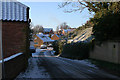
Church Walk, Eaton
This path links Church Lane with Main Street and is the route of the public footpath across the village.
Image: © Kate Jewell
Taken: 2 Jan 2010
0.01 miles
3
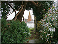
St Denys's Church, Eaton
From the garden gate, a snowy scene two days after Christmas Day 2005. The very plain gravestone of the author of Old Moore's Almanac who lived in the village may be seen in the churchyard. His wife is buried next to him in a relatively grand tomb.
Image: © Kate Jewell
Taken: 27 Dec 2005
0.01 miles
4
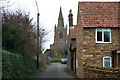
Church Lane, Eaton
12.05pm on Christmas day 2006
Compare with Image taken July 2005.
The house on the right has had a large extension built.
Image: © Kate Jewell
Taken: 25 Dec 2006
0.01 miles
5
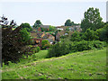
Eaton, Leicestershire
The church in Eaton is on a commanding high point in the village, see Image This view is from the southern edge of the church yard looking across Main Street, (houses in the foreground), to the old Methodist Church, centre distance. Eaton is cut in half by the OS grid line and Chapel Street, (marked by the houses leading up to the Methodist Church), is in Image
Image: © Kate Jewell
Taken: 8 Jul 2005
0.02 miles
6
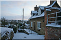
Main Street, Eaton
View from Vicarage Farm towards the centre of the village. The sunlit house in the centre is right on the grid square boundary with SK7928. The bank to the right rises up to a large modern house and garden, which in turn rises up to the church yard.
Image: © Kate Jewell
Taken: 3 Jan 2010
0.02 miles
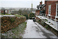
7
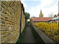
Church Walk, Eaton
A short but quite steep path.
Image: © Jonathan Thacker
Taken: 2 Apr 2021
0.02 miles
9

Eaton, Leicestershire
Ironstone village built on the southern side of a small valley. The church stands on the highest point of the village. (Taken fromSK 802290)
Image: © Kate Jewell
Taken: 17 Sep 2005
0.03 miles
10
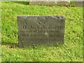
Belvoir Angel headstone, St Denys Churchyard, Eaton
To Eliz., wife of John Glen, d.1722. See also http://www.geograph.org.uk/photo/5180320
Image: © Alan Murray-Rust
Taken: 31 Oct 2016
0.03 miles