IMAGES TAKEN NEAR TO
Woolsthorpe, GRANTHAM, NG32 1NN
Introduction
This page details the photographs taken nearby to NG32 1NN by members of the Geograph project.
The Geograph project started in 2005 with the aim of publishing, organising and preserving representative images for every square kilometre of Great Britain, Ireland and the Isle of Man.

There are currently over 7.5m images from over14,400 individuals and you can help contribute to the project by visiting https://www.geograph.org.uk
Image Map
Images are licensed for reuse under creativecommons.org/licenses/by-sa/2.0
Notes
- Clicking on the map will re-center to the selected point.
- The higher the marker number, the further away the image location is from the centre of the postcode.
Image Listing (30 Images Found)
Images are licensed for reuse under creativecommons.org/licenses/by-sa/2.0
Image
Details
Distance
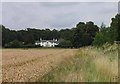
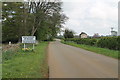
2
Looking north towards Woolsthorpe By Belvoir
Lincolnshire is on the left of this lane and Nottinghamshire is on the right
Image: © Richard Humphrey
Taken: 14 Aug 2016
0.03 miles
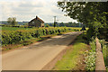
3
Woolsthorpe Lane at Castle Farm
Looking towards Woolsthorpe.
Image: © Jonathan Thacker
Taken: 5 May 2019
0.08 miles
5
Woolsthorpe Lane enters Woolsthorpe By Belvoir
Image: © J.Hannan-Briggs
Taken: 27 Apr 2014
0.08 miles
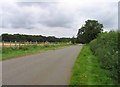
7
Woolsthorpe Lane
NCN route 64 on Woolsthorpe Lane looking south towards Castle Farm Cottage from the old churchyard
Image: © Richard Croft
Taken: 15 May 2014
0.10 miles
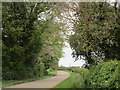
8
Woolsthorpe Lane towards Woolsthorpe by Belvoir
Image: © Andrew Tatlow
Taken: 23 Aug 2012
0.10 miles
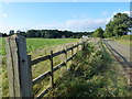
9
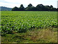
Sugar beet on The Devon
Farmland between Woolsthorpe By Belvoir and Harston
Image: © Richard Humphrey
Taken: 14 Aug 2016
0.11 miles
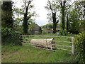
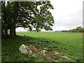
10
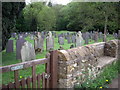
Churchyard of the 'old' church of St James', Woolsthorpe-by-Belvoir
The 'old' church on this site was burned down by Parliamentary forces in 1660. The raised area -centre back--is all that remains. Judging by the ages of the gravestones this was used as a cemetery for many years after this.
Image: © Ann Schmidt
Taken: 7 May 2007
0.13 miles