IMAGES TAKEN NEAR TO
Hawkridge Gardens, NOTTINGHAM, NG3 1LJ
Introduction
This page details the photographs taken nearby to Hawkridge Gardens, NG3 1LJ by members of the Geograph project.
The Geograph project started in 2005 with the aim of publishing, organising and preserving representative images for every square kilometre of Great Britain, Ireland and the Isle of Man.

There are currently over 7.5m images from over14,400 individuals and you can help contribute to the project by visiting https://www.geograph.org.uk
Image Map
Images are licensed for reuse under creativecommons.org/licenses/by-sa/2.0
Notes
- Clicking on the map will re-center to the selected point.
- The higher the marker number, the further away the image location is from the centre of the postcode.
Image Listing (103 Images Found)
Images are licensed for reuse under creativecommons.org/licenses/by-sa/2.0
Image
Details
Distance
1
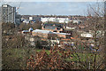
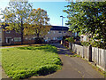
View from King Edward Park
Below can be seen former textile factories now converted to flats or light industrial use.
Image: © Alan Murray-Rust
Taken: 11 Feb 2007
0.08 miles
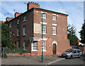
2

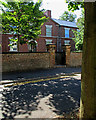
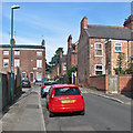
Plantaganet Street
A street of the 1850s, established as the Borough of Nottingham expanded beyond its mediaeval core. To the left is the central gable of Image
Image: © John Sutton
Taken: 30 Jun 2015
0.08 miles
3
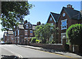
Plantaganet Street: The Working Man's Retreat
George Gill (1778-1855) was a philanthropist whose interests lay in education and the welfare of the elderly. He founded the People's College and built The Working Man's Retreat (retirement dwellings for the deserving) in 1852. It is in the satisfyingly plain style of many Nottingham buildings of the middle years of the nineteenth century, but not a listed building. The picture was taken against the light on a very sunny morning in late June.
Image: © John Sutton
Taken: 30 Jun 2015
0.08 miles
4
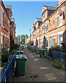
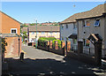
Harcourt Terrace
Looking from the Lamartine Street end towards Robin Hood Terrace on a bright June morning.
Image: © John Sutton
Taken: 30 Jun 2015
0.09 miles
5
Paxton Gardens, St Ann's
Paxton Gardens leads off Stonebridge Road. This area was comprehensively redeveloped in the 1960s and '70s when vast numbers of 19th century houses, built for the working poor and widely condemned as slums, were demolished.
Image: © Stephen McKay
Taken: 16 Oct 2022
0.09 miles
6
Paxton Gardens, St Ann's
The modern St Ann's, a large Nottingham inner city social housing area, is a good example of a Radburn estate - a design that was very fashionable from the 1960s to the 1980s. The idea was to ruthlessly separate cars and pedestrians so that all the houses face on to walkways and cars are kept on access roads behind walls at the rear. In this view rows of terraced houses look out on to a grassed patch with mature trees perhaps intended to emulate a village green. It does not look unpleasant on a sunny morning but experience with Radburn estates in general suggests that the confusing layout with myriad cut throughs and paths (and parking areas hidden from view) is unpopular and encourages crime. St Ann's was comprehensively redeveloped in the 1970s after the previous housing stock of poor quality 19th century terraced houses - specifically built for the working poor - was demolished.
Image: © Stephen McKay
Taken: 16 Oct 2022
0.09 miles
7
Robin Hood Terrace and Harcourt Terrace
Robin Hood Terrace (ahead, left) dates from the middle of the nineteenth century, the two-storey houses on Harcourt and Foljambe Terraces from later in the Victorian period.
Image: © John Sutton
Taken: 16 Aug 2016
0.09 miles
8
A sunny morning in Lamartine Street
Looking towards Foljambe and Harcourt Terraces from the corner of Plantaganet Street. These streets are some of those built as the borough expanded from its mediaeval core after the 1845 Enclosure Act.
Image: © John Sutton
Taken: 30 Jun 2015
0.10 miles
9
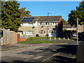
Across St Ann's
Houses like these replaced the Victorian terraces of the St Ann's district in the 1970s, the City Council learning from the mistaken deck-access flats experiment of the 1960s (the flats at Balloon Wood, Old Basford and Hyson Green were demolished by the early 1980s and replaced by low-density housing). St Andrew's Church on Mansfield Road shows on the skyline, above the large textile factory on St Ann's Hill Road.
Image: © John Sutton
Taken: 30 Jun 2015
0.10 miles
10
Campbell Grove
An elegant terrace connected to Robin Hood Terrace and backing on to Promenade. This is the east end of the north row. The end terrace was once a Shipstone's off-licence: its corner door and shop front have been replaced with new brickwork and appropriate twelve-light sash windows. The row is Grade II listed: http://www.britishlistedbuildings.co.uk/en-454876-1-to-19-campbell-grove-#.VeDY3SiwHZY .
Image: © John Sutton
Taken: 22 Aug 2015
0.10 miles