IMAGES TAKEN NEAR TO
Alnwick Way, GRANTHAM, NG31 8UJ
Introduction
This page details the photographs taken nearby to Alnwick Way, NG31 8UJ by members of the Geograph project.
The Geograph project started in 2005 with the aim of publishing, organising and preserving representative images for every square kilometre of Great Britain, Ireland and the Isle of Man.

There are currently over 7.5m images from over14,400 individuals and you can help contribute to the project by visiting https://www.geograph.org.uk
Image Map
Images are licensed for reuse under creativecommons.org/licenses/by-sa/2.0
Notes
- Clicking on the map will re-center to the selected point.
- The higher the marker number, the further away the image location is from the centre of the postcode.
Image Listing (17 Images Found)
Images are licensed for reuse under creativecommons.org/licenses/by-sa/2.0
Image
Details
Distance
1
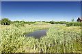
Wildlife pond
What the developers call a 'wildlife pond'. In reality it exists to bring the spring to the surface and channel it off into Running Furrows and potentially the balancing pond, avoiding flooding.
Image: © Richard Bamford
Taken: 25 May 2020
0.10 miles
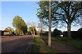
2
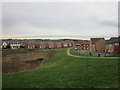
Ever expanding Grantham
New estates between Barrowby Road and Gonerby Hill Foot.
Image: © Jonathan Thacker
Taken: 9 Jan 2020
0.11 miles
3
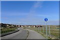
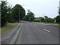
Lauriston Road, Grantham
Looking towards part of the Poplar Farm 'urban extension'. The development anticipates almost 2,000 dwellings with school and other community facilities.
Image: © Tim Heaton
Taken: 9 Mar 2021
0.16 miles
6
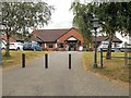
Muddle Go Nowhere, Grantham
Large pub/restaurant off the A52, Barrowby Road, approaching Grantham.
Image: © David Dixon
Taken: 8 Sep 2013
0.22 miles
8
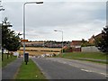
Greenfield Incursion
Property development gradually encroaches across the farmland near to Grantham.
Image: © Donnylad
Taken: 1 Jun 2007
0.22 miles
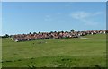
9
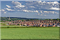
Further greenfield incursion
Continued housing development on the greenfield land in Grantham. This is the Poplar Farm estate which occupies the area historically shown as Little Gonerby. Interesting to contrast with previous submissions from 13 years ago. The next phases are destined to cover the field in the foreground of the image and ultimately extend up to Gonerby Tunnel.
St Wulram's Church can be seen in the background and marks the centre of the historic Town.
Image: © Richard Bamford
Taken: 13 Jun 2020
0.23 miles
10
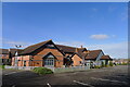
Miller and Carter Steakhouse, Barrowby Road, Grantham
Temporarily closed
Image: © Tim Heaton
Taken: 9 Mar 2021
0.23 miles