IMAGES TAKEN NEAR TO
Caunt Road, GRANTHAM, NG31 7FZ
Introduction
This page details the photographs taken nearby to Caunt Road, NG31 7FZ by members of the Geograph project.
The Geograph project started in 2005 with the aim of publishing, organising and preserving representative images for every square kilometre of Great Britain, Ireland and the Isle of Man.

There are currently over 7.5m images from over14,400 individuals and you can help contribute to the project by visiting https://www.geograph.org.uk
Image Map
Images are licensed for reuse under creativecommons.org/licenses/by-sa/2.0
Notes
- Clicking on the map will re-center to the selected point.
- The higher the marker number, the further away the image location is from the centre of the postcode.
Image Listing (13 Images Found)
Images are licensed for reuse under creativecommons.org/licenses/by-sa/2.0
Image
Details
Distance
1
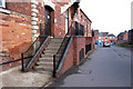
Built to Last - The Old Malthouse, Springfield Road
The listed structure of the Old Malthouse (1834) on Springfield Road has been converted internally into small business units. This has been carefully done, with major features of the building retained - its old malting floors; the hoist for loading sacks (up through the protruding part shown in this picture); even the hollow cast-iron pillars down which barley samples fell into trays for analysis.
Image: © David Harris
Taken: 11 May 2005
0.13 miles
2
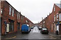
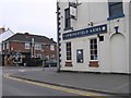
Victoria Street
Bricked up windows at the corner shop and barred windows opposite.
Image: © Andrew Tatlow
Taken: 19 Apr 2006
0.14 miles
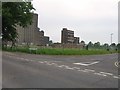
3
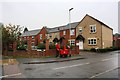
Springfield Road at Harris Way junction
Ordnance Survey records indicate that in 1951 there was a social club here on which a benchmark was cut. See www.bench-marks.org.uk/bm116241
Image: © phil Richards
Taken: 9 Sep 2019
0.16 miles
4
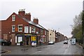
Springfield Road
Terraced houses in Grantham with a corner shop.
Image: © Andrew Tatlow
Taken: 19 Apr 2006
0.18 miles
7
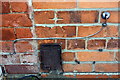
Benchmark on #43 Springfield Road
Ordnance Survey cut mark benchmark described on the Bench Mark Database at www.bench-marks.org.uk/111447
Image: © phil Richards
Taken: 9 Sep 2019
0.23 miles
8
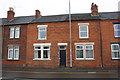
No. 43 Springfield Road
There is an OS benchmark Image on the front of the house at its junction with the house to its left
Image: © phil Richards
Taken: 9 Sep 2019
0.23 miles
9
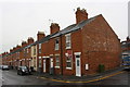
Victoria Street houses at Stamford Street junction
There is an OS benchmark Image on the side of the nearest house next to a wooden fence panel at the right hand edge of the image
Image: © phil Richards
Taken: 9 Sep 2019
0.23 miles
10
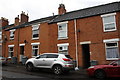
Victoria Street houses
There is an OS Benchmark Image on the bricks at the left hand side of the alleyway between the two parked cars
Image: © phil Richards
Taken: 9 Sep 2019
0.23 miles