IMAGES TAKEN NEAR TO
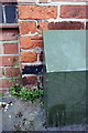
Newton Street, GRANTHAM, NG31 6HA
Introduction
This page details the photographs taken nearby to Newton Street, NG31 6HA by members of the Geograph project.
The Geograph project started in 2005 with the aim of publishing, organising and preserving representative images for every square kilometre of Great Britain, Ireland and the Isle of Man.

There are currently over 7.5m images from over14,400 individuals and you can help contribute to the project by visiting https://www.geograph.org.uk
Image Map
Images are licensed for reuse under creativecommons.org/licenses/by-sa/2.0
Notes
- Clicking on the map will re-center to the selected point.
- The higher the marker number, the further away the image location is from the centre of the postcode.
Image Listing (274 Images Found)
Images are licensed for reuse under creativecommons.org/licenses/by-sa/2.0
Image
Details
Distance
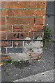
1
Benchmark on #16 St Catherine's Road
Ordnance Survey cut mark benchmark described on the Bench Mark Database at http://www.bench-marks.org.uk/bm57029
Image: © Roger Templeman
Taken: 19 Apr 2014
0.02 miles
2
Paragon Recruitment, #15 St Catherine's Road
There is an OS benchmark Image left of the green box under the Newton Street sign
Image: © Roger Templeman
Taken: 19 Apr 2014
0.02 miles
3
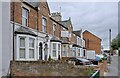
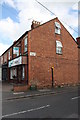
Homes and Businesses
A small row of superior speculative built houses in St Catherine's road, dating from the late 19th century. Now a mixture of rented offices and "houses of multiple occupancy".
Image: © Bob Harvey
Taken: 14 Jul 2024
0.04 miles
4
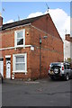
#6 Eton Street
There is an OS benchmark Image on the front of the house at the near corner
Image: © Roger Templeman
Taken: 19 Apr 2014
0.05 miles
5
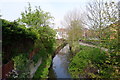
The River Witham, Grantham
From the footbridge at the end of College Street
Image: © Tim Heaton
Taken: 21 Apr 2014
0.05 miles
6
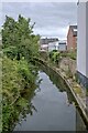
The River Witham
Looking upstream from the parapet of Image
Image: © Bob Harvey
Taken: 14 Jul 2024
0.05 miles
7
A caged river
Blocked between the embankments seen in Image, even the parapets of the bridge (this is the upstream one of Image) look like an attempt to contain and tame the river.
Image: © Bob Harvey
Taken: 14 Jul 2024
0.05 miles
8
Benchmark on #6 Eton Road
Ordnance Survey cut mark benchmark described on the Bench Mark Database at http://www.bench-marks.org.uk/bm57238
Image: © Roger Templeman
Taken: 19 Apr 2014
0.05 miles
9
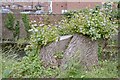
Determination to live
Someone in authority felled this tree and left the stump. I imagine it was a proud specimen, but someone felt it threatened to fall into the river, or something. The tree, however, did not want to co-operate in its demise and has attempted to re-grow with some profusion. That lifts my heart.
Image: © Bob Harvey
Taken: 14 Jul 2024
0.05 miles
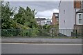
10
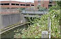
And where is the beauty
This is the bridge over the River Witham for St Catherine's road in Grantham. It is a starkly utilitarian view, except for the exuberant growth of wild plants next to the river. The ugliest building is the multi storey car park of Welham street, albeit the adjacent apartment block is a close second. The bridge can be seen again in Image
Image: © Bob Harvey
Taken: 14 Jul 2024
0.05 miles