IMAGES TAKEN NEAR TO
London Road, GRANTHAM, NG31 6ET
Introduction
This page details the photographs taken nearby to London Road, NG31 6ET by members of the Geograph project.
The Geograph project started in 2005 with the aim of publishing, organising and preserving representative images for every square kilometre of Great Britain, Ireland and the Isle of Man.

There are currently over 7.5m images from over14,400 individuals and you can help contribute to the project by visiting https://www.geograph.org.uk
Image Map
Images are licensed for reuse under creativecommons.org/licenses/by-sa/2.0
Notes
- Clicking on the map will re-center to the selected point.
- The higher the marker number, the further away the image location is from the centre of the postcode.
Image Listing (328 Images Found)
Images are licensed for reuse under creativecommons.org/licenses/by-sa/2.0
Image
Details
Distance
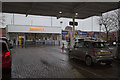
2
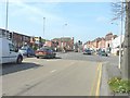
Traffic lights on London Road, Grantham
I assume they were installed when the Sainsbury's supermarket was built to control traffic entering and leaving the store. This access road is seen here as the next right turn on London Road.
Image: © John Baker
Taken: 30 Mar 2012
0.03 miles
4
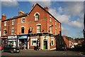
Interesting ornamentation
Look above the shop front of design works to see an interesting, ornamented building.
Image: © Richard Croft
Taken: 2 Feb 2007
0.04 miles
5
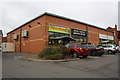
'Farmfoods', London Road
There was previously a garage at this location
Image: © Roger Templeman
Taken: 7 Apr 2016
0.04 miles
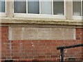
7

Benchmark on #41 Oxford Street
Ordnance Survey cut mark benchmark described on the Bench Mark Database at http://www.bench-marks.org.uk/bm57239
Image: © Roger Templeman
Taken: 19 Apr 2014
0.05 miles
8
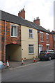
Oxford Street houses
There is an OS benchmark Image on the front of the yellow house at its junction with #42, 'Ivy Cottage'.
Image: © Roger Templeman
Taken: 19 Apr 2014
0.05 miles
9
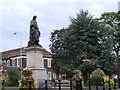
Foundation stones, former Salvation Army citadel, Grantham
Providing a concise description of the structure of the organisation. See http://www.geograph.org.uk/photo/5282767 for location.
Image: © Alan Murray-Rust
Taken: 9 Feb 2017
0.05 miles
10
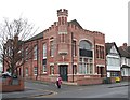
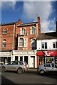
London Road, Grantham, Lincs.
A former church building - now an office complex - on the main A52 road. The town centre lies 2-3 minutes walk away on the photographer's right.
Image: © David Hallam-Jones
Taken: 23 Dec 2017
0.05 miles