IMAGES TAKEN NEAR TO
Bede Ling, NOTTINGHAM, NG2 7RP
Introduction
This page details the photographs taken nearby to Bede Ling, NG2 7RP by members of the Geograph project.
The Geograph project started in 2005 with the aim of publishing, organising and preserving representative images for every square kilometre of Great Britain, Ireland and the Isle of Man.

There are currently over 7.5m images from over14,400 individuals and you can help contribute to the project by visiting https://www.geograph.org.uk
Image Map
Images are licensed for reuse under creativecommons.org/licenses/by-sa/2.0
Notes
- Clicking on the map will re-center to the selected point.
- The higher the marker number, the further away the image location is from the centre of the postcode.
Image Listing (93 Images Found)
Images are licensed for reuse under creativecommons.org/licenses/by-sa/2.0
Image
Details
Distance
1
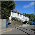
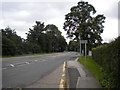
Wilford Lane: Bede-Ling
A short terrace off Wilford Lane, photographed on a bright July morning.
Image: © John Sutton
Taken: 24 Jul 2018
0.00 miles
2
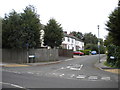
Bede-Ling, West Bridgford
Located off Wilford Lane just east of Wilford, this bizarrely named cul-de-sac serves only a small number of houses.
Image: © Richard Vince
Taken: 1 Sep 2012
0.02 miles
3
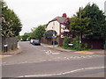
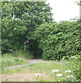
Nottingham - NG2 (Wilford Area)
Bede Ling, off Wilford Lane (the B679). Ling appears to be an alternative name for heather, a plant that thrives in well drained, sandy situations. As to the name Bede, mention is made in the Thoroton Society Transactions (Vol. XVIII) of “a chantry house in Wollaton near the Rectory house, the lower storey whereof was occupied by Bede-folk ...." Thus, since the Venerable Bede is known to have exerted a great an influence along the Trent Valley and also that the Benedictines were present at Lenton Priory in 1872, it seems possible that this area of sandy moorland was once owned by these “Bede folk”. More recently, a rifle range existed in a field at the closed end of this cul-de-sac.
Image: © David Hallam-Jones
Taken: 2 Jun 2012
0.02 miles
4
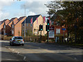
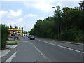
Wilford Lane, West Bridgford
Linden Homes' Wilford Fields housing development is on the right.
Image: © Stephen McKay
Taken: 9 Oct 2019
0.03 miles
5
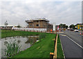
Nottingham - NG2 - Wilford Area
The Wilford Road (B679) entrance/exit to the former Rushcliffe Council municipal waste tip. Once the tip was full the area was levelled off and covered, in part by ash from the Ratcliffe-on-Soar coal-fired power station, and it is currently open land for recreational use, albeit semi-permanently under threat of being built upon.
Image: © David Hallam-Jones
Taken: 2 Jun 2012
0.03 miles
7
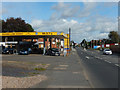
Wilford Lane, West Bridgford
Wilford Lane Garage, with its associated Barn Cafe, is on the left; a new housing development is appearing on the opposite side of the road.
Image: © Stephen McKay
Taken: 9 Oct 2019
0.05 miles
8
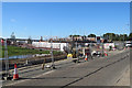
Building houses on Wilford Lane
Single-line traffic controlled by temporary traffic lights.
Image: © John Sutton
Taken: 24 Jul 2018
0.05 miles
10
Wilford Lane: new houses and road works
The Wilford Fields estate is being built on former playing fields south of Wilford Lane. The man in the orange high-vis jacket was chalking the tarmac ahead of road marking.
Image: © John Sutton
Taken: 5 Sep 2018
0.06 miles