IMAGES TAKEN NEAR TO
Rivermead, Wilford Lane, NOTTINGHAM, NG2 7RF
Introduction
This page details the photographs taken nearby to Rivermead, Wilford Lane, NG2 7RF by members of the Geograph project.
The Geograph project started in 2005 with the aim of publishing, organising and preserving representative images for every square kilometre of Great Britain, Ireland and the Isle of Man.

There are currently over 7.5m images from over14,400 individuals and you can help contribute to the project by visiting https://www.geograph.org.uk
Image Map
Images are licensed for reuse under creativecommons.org/licenses/by-sa/2.0
Notes
- Clicking on the map will re-center to the selected point.
- The higher the marker number, the further away the image location is from the centre of the postcode.
Image Listing (265 Images Found)
Images are licensed for reuse under creativecommons.org/licenses/by-sa/2.0
Image
Details
Distance
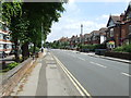
2
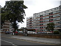
Early evening on Wilford Lane
A No 3 bus is heading for the city centre not long after 6.30 on a September evening. The Rivermead flats are on the left.
Image: © John Sutton
Taken: 21 Sep 2021
0.01 miles
3
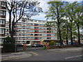
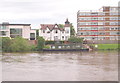
Rivermead Flats
Flats at Wilford with views over the River Trent
Image: © Richard Croft
Taken: 15 Jul 2011
0.02 miles
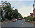
4
West Bridgford: Rivermead, Wilford Lane
These blocks were built in the 1960s. This is the Wilford Lane side - the flats with river views are on the far side.
Image: © John Sutton
Taken: 26 Sep 2018
0.03 miles
5
Rivermead flats, West Bridgford
Part of the Rivermead development of flats on Wilford Lane, West Bridgford. The small building in the car park contains two shops.
Image: © Richard Vince
Taken: 1 Sep 2012
0.03 miles
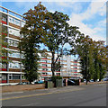
6
Rivermead, West Bridgford
Part of a large apartment complex which is completely out of scale with its surroundings.
Image: © Jonathan Thacker
Taken: 1 May 2015
0.03 miles
7
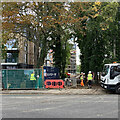
Riverside: new flats on Wilford Lane
New flats, some with river views, are going up on a site on Wilford Lane, next to the Rivermead flats which have been there since the 1960s. Image] (April 2022) shows an earlier stage of the work, from a different angle.
Image: © John Sutton
Taken: 8 Sep 2022
0.03 miles
8
West Bridgford: Rivermead and Riverside flats
Beyond the Rivermead flats, built in the 1960s, a new block, Riverside, also approached from Wilford Lane, is going up. Image] shows it from the road.
Image: © John Sutton
Taken: 6 Sep 2021
0.04 miles
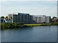
9
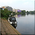
Nottingham - NG2 (Wilford Area)
Four contrasting residential options on the side of the River Trent, as seen from Victoria Embankment. The midpoint between the two river banks marks the boundary between the Municipal Borough of Rushcliffe and the City of Nottingham.
Image: © David Hallam-Jones
Taken: 9 Jun 2012
0.04 miles
10
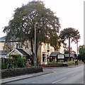
Wilford Lane: The Beeches Hotel
Photographed against the light on a September evening.
Image: © John Sutton
Taken: 5 Sep 2018
0.04 miles