IMAGES TAKEN NEAR TO
Sandringham Avenue, NOTTINGHAM, NG2 7QS
Introduction
This page details the photographs taken nearby to Sandringham Avenue, NG2 7QS by members of the Geograph project.
The Geograph project started in 2005 with the aim of publishing, organising and preserving representative images for every square kilometre of Great Britain, Ireland and the Isle of Man.

There are currently over 7.5m images from over14,400 individuals and you can help contribute to the project by visiting https://www.geograph.org.uk
Image Map
Images are licensed for reuse under creativecommons.org/licenses/by-sa/2.0
Notes
- Clicking on the map will re-center to the selected point.
- The higher the marker number, the further away the image location is from the centre of the postcode.
Image Listing (521 Images Found)
Images are licensed for reuse under creativecommons.org/licenses/by-sa/2.0
Image
Details
Distance
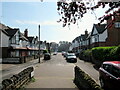
1
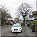
Sandringham Avenue
One of three culs-de-sac between Loughborough Road and the right bank of the Trent. The City of Nottingham War Memorial is in the background, on the other side of the river.
Image: © John Sutton
Taken: 12 Apr 2013
0.02 miles
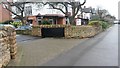
2
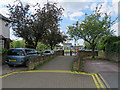
West Bridgford: Sandringham Avenue flood prevention
The stone wall, ramped path and out-of-picture gates are flood-prevention measures. David Hallam-Jones’s Image] shows the flood gates on the Embankment side of the wall at nearby Balmoral Avenue. The City of Nottingham War Memorial is on the other side of the River Trent.
Image: © John Sutton
Taken: 12 May 2019
0.02 miles
3
Trent Embankment
The West Bridgford side near Sandringham Avenue.
Image: © Alan Murray-Rust
Taken: 23 Sep 2008
0.03 miles
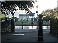
4
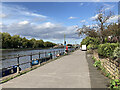
Path alongside the River Trent near the County Hall
Image: © Roy Hughes
Taken: 16 Apr 2022
0.03 miles
7
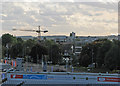
Over Loughborough Road
A view across Bridgford towards Clifton, with a crane on the site of the demolished Beckett School buildings, taken from the Radcliffe Road End of Trent Bridge Cricket Ground on the penultimate day of the season. The back few rows of seats in the William Clarke Stand are in the foreground.
Image: © John Sutton
Taken: 24 Sep 2015
0.04 miles
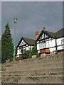
8
Evening sunlight, Sandringham Avenue
The end of one of the culs-de-sac which run from Loughborough Road to the Embankment is shadowy, but on the other side of the Trent low evening sunlight catches the City of Nottingham War Memorial.
Image: © John Sutton
Taken: 13 Jun 2013
0.04 miles
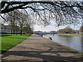
9
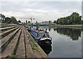
West Bridgford: along the embankment to Trent Bridge
The concrete embankment steps on the West Bridgford side of the River Trent match the Victoria Embankment steps on the city side of the River. There had been a lot of rain in the morning, but when this picture was taken just after 2.30 it had become a pleasant late-summer afternoon - and play between Nottinghamshire and Middlesex at Trent Bridge (where I was heading) was due to begin at three o'clock.
Image: © John Sutton
Taken: 26 Sep 2023
0.04 miles
10
A grey September morning by the Trent
A view along the Embankment steps towards the Suspension Bridge. The crane is working on the former site of Becket School, where flats are being built. By way of comparison, see Image] (May 2010).
Image: © John Sutton
Taken: 22 Sep 2015
0.05 miles