IMAGES TAKEN NEAR TO
Chantrey Road, NOTTINGHAM, NG2 7NR
Introduction
This page details the photographs taken nearby to Chantrey Road, NG2 7NR by members of the Geograph project.
The Geograph project started in 2005 with the aim of publishing, organising and preserving representative images for every square kilometre of Great Britain, Ireland and the Isle of Man.

There are currently over 7.5m images from over14,400 individuals and you can help contribute to the project by visiting https://www.geograph.org.uk
Image Map
Images are licensed for reuse under creativecommons.org/licenses/by-sa/2.0
Notes
- Clicking on the map will re-center to the selected point.
- The higher the marker number, the further away the image location is from the centre of the postcode.
Image Listing (66 Images Found)
Images are licensed for reuse under creativecommons.org/licenses/by-sa/2.0
Image
Details
Distance
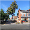
1
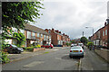
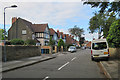
West Bridgford: differing styles on Chantrey Road
Looking from the Loughborough Road end on a cloudy July morning. Bridgford mushroomed in the last twenty years of the nineteenth century and the Edwardian period (and again between the wars and thereafter).
Image: © John Sutton
Taken: 27 Jul 2023
0.02 miles
2
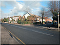
West Bridgford
A photograph of the West Bridgford section of the Nottingham to Loughborough road.
Image: © Dennis Turner
Taken: 26 Dec 2005
0.04 miles
3
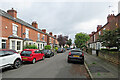
West Bridgford: along Carlyle Road
Bridgford mushroomed in the last twenty years of the nineteenth century and the Edwardian period (and again between the wars and thereafter).
Image: © John Sutton
Taken: 27 Jul 2023
0.04 miles
4
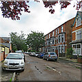
West Bridgford: along Charnwood Grove
Three-storey houses are perhaps less common in Bridgford than in other Victorian and Edwardian parts of Nottingham.
Image: © John Sutton
Taken: 27 Jul 2023
0.05 miles
5

West Bridgford
Recreating this 'First' for the square https://www.geograph.org.uk/photo/96395 , complete with the same minimal title. This is Loughborough Road at the junction of Chantrey Road.
Image: © Alan Murray-Rust
Taken: 10 Oct 2021
0.05 miles
6
West Bridgford: Carlyle Road
Carlyle Road runs from Melton Road (just behind the camera) to Loughborough Road.
Image: © John Sutton
Taken: 26 Sep 2018
0.06 miles
7
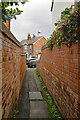
West Bridgford: North Road to Carlyle Road
In Nottingham alleys like this are called twitchels.
Image: © John Sutton
Taken: 27 Jul 2023
0.07 miles
8
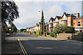
West Bridgford: Loughborough Road
Typical Bridgford villas near the corner of Victoria Road, photographed on a bright September morning.
Image: © John Sutton
Taken: 7 Sep 2018
0.09 miles
9
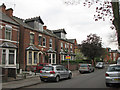
Victoria Road
Bad light stopped play early on the first day of the County Championship season at Trent Bridge, so I went for a look at Victoria Road. My great grandparents and later my great aunts lived at the semi with the traffic cone in front of its bay window. Its interior remained an Edwardian time capsule into the 1960s. For a view of it in the 1920s, see Image
(Notts began their defence of the title by beating Hampshire by 9 wickets on the third day.)
Image: © John Sutton
Taken: 14 Apr 2011
0.10 miles
10
West Bridgford: the corner of Charnwood Grove
A view across Melton Road, taken on a sunny September morning.
Image: © John Sutton
Taken: 7 Sep 2018
0.10 miles