IMAGES TAKEN NEAR TO
Edward Road, NOTTINGHAM, NG2 5GP
Introduction
This page details the photographs taken nearby to Edward Road, NG2 5GP by members of the Geograph project.
The Geograph project started in 2005 with the aim of publishing, organising and preserving representative images for every square kilometre of Great Britain, Ireland and the Isle of Man.

There are currently over 7.5m images from over14,400 individuals and you can help contribute to the project by visiting https://www.geograph.org.uk
Image Map
Images are licensed for reuse under creativecommons.org/licenses/by-sa/2.0
Notes
- Clicking on the map will re-center to the selected point.
- The higher the marker number, the further away the image location is from the centre of the postcode.
Image Listing (481 Images Found)
Images are licensed for reuse under creativecommons.org/licenses/by-sa/2.0
Image
Details
Distance
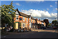
1
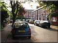
Richmond Road on a May evening
West Bridgford's population rose from 293 in 1881 to 7,018 twenty years later. It is essentially a Victorian and Edwardian suburb, which is why the narrow strip of new buildings between Radcliffe Road and Bridgford Park and running parallel to Stratford Road between Bridgford Road and Melton Road shows up so clearly on aerial photos. The houses in Cricketers Close and Radcliffe Mount which close off the end of Richmond Road stand where there was once a railway embankment, now levelled, which carried the Nottingham-Melton-Oakham-Corby-Kettering line on which the fastest trains from Nottingham Midland to London St Pancras ran.
Image: © John Sutton
Taken: 4 May 2011
0.03 miles
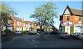
2
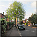
Evening sunlight, Edward Road
The kind of green you only see in spring.
Image: © John Sutton
Taken: 27 Apr 2014
0.03 miles
3
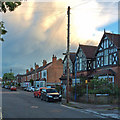
Edward Road with rainclouds
West Bridgford at quarter to nine on a May evening.
Image: © John Sutton
Taken: 18 May 2015
0.03 miles
4
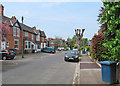
Ella Road and a pollarded tree
Looking towards the corner of Edward Road on a May afternoon.
Image: © John Sutton
Taken: 11 May 2017
0.04 miles
5
Building work on Edward Road
The former shops on the corner of Ella Road are being converted. Image] shows the state of play a month before.
Image: © John Sutton
Taken: 18 May 2015
0.04 miles
6
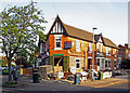
Alterations on Edward Road
Converting the shop on the corner of Ella Road. For an idea of how things were, see Image], also taken on a sunny April evening.
Image: © John Sutton
Taken: 21 Apr 2015
0.04 miles
7
Evening sunlight, Ella Road
A view from the corner of Edward Road on a bright late-April evening.
Image: © John Sutton
Taken: 29 Apr 2013
0.05 miles
8
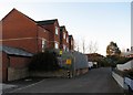
Radcliffe Mount: once a railway embankment
The direct line from Nottingham to St Pancras via Melton Mowbray closed in 1968. Some time later parts of the embankment which carried it through West Bridgford were levelled and the land used for housing. These new buildings contrast with Victorian and Edwardian Bridgford and show clearly on aerial photos.
See Image], Image], Image], Image], Image] and others.
Image: © John Sutton
Taken: 6 Apr 2012
0.05 miles
9
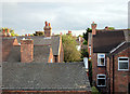
Bridgford rooftops
The backs of houses on Edward Road (left) seen from a second-floor window in The Grantham Hotel.
Image: © John Sutton
Taken: 24 Aug 2010
0.05 miles
10
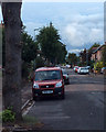
An August evening on Edward Road
Rainclouds over the city.
Image: © John Sutton
Taken: 23 Aug 2015
0.06 miles