IMAGES TAKEN NEAR TO
Crosby Road, NOTTINGHAM, NG2 5GH
Introduction
This page details the photographs taken nearby to Crosby Road, NG2 5GH by members of the Geograph project.
The Geograph project started in 2005 with the aim of publishing, organising and preserving representative images for every square kilometre of Great Britain, Ireland and the Isle of Man.

There are currently over 7.5m images from over14,400 individuals and you can help contribute to the project by visiting https://www.geograph.org.uk
Image Map
Images are licensed for reuse under creativecommons.org/licenses/by-sa/2.0
Notes
- Clicking on the map will re-center to the selected point.
- The higher the marker number, the further away the image location is from the centre of the postcode.
Image Listing (305 Images Found)
Images are licensed for reuse under creativecommons.org/licenses/by-sa/2.0
Image
Details
Distance
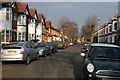
1
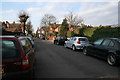
Trevelyan Road, West Bridgford
Looking from Ella Road towards Crosby Road. There are no houses on this stretch of Trevelyan Road which links Ella Road and Crosby Road. The streets in this part of West Bridgford are lined with trees that are heavily pollarded every few years.
Image: © Kate Jewell
Taken: 11 Mar 2010
0.01 miles
2
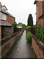
A wet afternoon in Bridgford
The twitchel leads from Crosby Road (behind the camera) to Edward Road and Bridgford Park.
Image: © John Sutton
Taken: 26 May 2014
0.02 miles
3
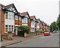
West Bridgford: Crosby Road
Near the corner of Trevelyan Road on a cloudy June morning.
Image: © John Sutton
Taken: 20 Jun 2017
0.02 miles
4
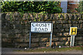
Crosby Road street sign, West Bridgford
Image: © Kate Jewell
Taken: 11 Mar 2010
0.03 miles
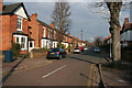
5
Crosby Road, West Bridgford
Looking towards the north end of Crosby Road where it meets Edward Road in Image Again, as in many of the streets around here, there is a mix of styles and periods of residential housing.
Image: © Kate Jewell
Taken: 11 Mar 2010
0.03 miles
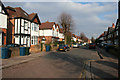
6
Crosby Road, West Bridgford
From the southerly junction with Edward Road. Edward Road makes a sweeping curve between Radcliffe Road to the north and Ella Road and Albert Road to the south east, see the map. Crosby Road cuts across the semi-circle meeting with Edward Road at both ends.
Image: © Kate Jewell
Taken: 11 Mar 2010
0.04 miles
7
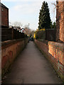
Between Crosby Road and Edward Road
Although Crosby Road meets up with semi-circular Edward Road at both ends this path links both roads half way along. It also allows easy access to Bridgford Park and Playing Field via another path off Edward Road, See Image
Image: © Kate Jewell
Taken: 11 Mar 2010
0.05 miles
8
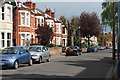
Crosby Road, West Bridgford
The streets to the north east of West Bridgford are mainly semi-detached Victorian and Edwardian villas.
Image: © Kate Jewell
Taken: 1 May 2008
0.05 miles
9
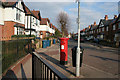
Post box on Edward Road
At the entrance to Bridgford Park.
Image: © Kate Jewell
Taken: 11 Mar 2010
0.05 miles
10
Edward Road, West Bridgford
Looking towards Radcliffe Road and Trent Bridge. The houses to the left back onto the large playing field to the north of Bridgford Park.
Image: © Kate Jewell
Taken: 11 Mar 2010
0.06 miles