IMAGES TAKEN NEAR TO
Crink Lane, SOUTHWELL, NG25 0TJ
Introduction
This page details the photographs taken nearby to Crink Lane, NG25 0TJ by members of the Geograph project.
The Geograph project started in 2005 with the aim of publishing, organising and preserving representative images for every square kilometre of Great Britain, Ireland and the Isle of Man.

There are currently over 7.5m images from over14,400 individuals and you can help contribute to the project by visiting https://www.geograph.org.uk
Image Map
Images are licensed for reuse under creativecommons.org/licenses/by-sa/2.0
Notes
- Clicking on the map will re-center to the selected point.
- The higher the marker number, the further away the image location is from the centre of the postcode.
Image Listing (38 Images Found)
Images are licensed for reuse under creativecommons.org/licenses/by-sa/2.0
Image
Details
Distance
1
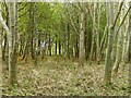
Plantation woodland near Park Farm
The 1:25000 mapping still shows this part of the wood as open land, although the size of the trees shows that the planting must be 20-30 years old.
Image: © Alan Murray-Rust
Taken: 9 Nov 2021
0.05 miles
2
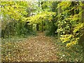
Autumn colours
Footpath through woodland between Southwell and Brinkley.
Image: © Alan Murray-Rust
Taken: 9 Nov 2021
0.08 miles
4
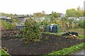
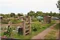
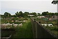
Southwell allotments
This is a large area of allotments off the Fiskerton Road.
Image: © Alan Murray-Rust
Taken: 9 Nov 2021
0.11 miles
6
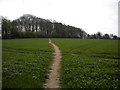
Path towards Park Farm from Southwell
The path continues through the copse at the top of the hill.
Image: © Richard Vince
Taken: 17 Apr 2014
0.14 miles
7
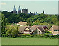
Southwell NG25, Notts.
A cluster of houses on Farthingate Close with the Minster seen from a footpath linking Clink Lane and Farthingate Close; part of the "Bramley Apple Trail". The caps to the minster's towers were rebuilt in 1880, to the original pattern, following a fire in 1711.
Image: © David Hallam-Jones
Taken: 25 May 2013
0.15 miles
8
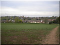
Southwell from the south east
A view from a footpath that heads south east from Southwell towards Park Farm. The houses nearest to the camera are on Fathingate Close, while the towers of Southwell Minster can be seen on the horizon.
Image: © Richard Vince
Taken: 17 Apr 2014
0.17 miles
9
Footpath through the rape
Heading towards Easthorpe. I was glad I had not decided to include this section of path on my route - another time of year would be better.
Image: © Alan Murray-Rust
Taken: 9 Jun 2008
0.17 miles
10

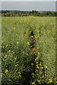
Path through a rape field
The first few yards can be followed without much difficulty, but beyond that . . .
Nevertheless, it shows as a well used route on aerial photographs with less well developed crop.
Image: © Alan Murray-Rust
Taken: 9 Jun 2008
0.18 miles