IMAGES TAKEN NEAR TO
Trinity Road, SOUTHWELL, NG25 0NW
Introduction
This page details the photographs taken nearby to Trinity Road, NG25 0NW by members of the Geograph project.
The Geograph project started in 2005 with the aim of publishing, organising and preserving representative images for every square kilometre of Great Britain, Ireland and the Isle of Man.

There are currently over 7.5m images from over14,400 individuals and you can help contribute to the project by visiting https://www.geograph.org.uk
Image Map
Images are licensed for reuse under creativecommons.org/licenses/by-sa/2.0
Notes
- Clicking on the map will re-center to the selected point.
- The higher the marker number, the further away the image location is from the centre of the postcode.
Image Listing (73 Images Found)
Images are licensed for reuse under creativecommons.org/licenses/by-sa/2.0
Image
Details
Distance
1
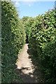
Footpath along the ridge
The footpath follows the ridge of the high ground to the west of Southwell Town Centre and acts as a divide between housing development on either side
Image: © Alan Murray-Rust
Taken: 19 Jun 2008
0.05 miles
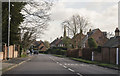
2
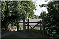
The top of Trinity Road
The link from Trinity Road onto the footpath along the ridge
Image: © Alan Murray-Rust
Taken: 19 Jun 2008
0.06 miles
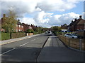
3
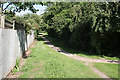
Ridge footpath looking west
At the top of Trinity Road. There is housing development on both side, but the footpath is uninterrupted for nearly 1 kilometre
Image: © Alan Murray-Rust
Taken: 19 Jun 2008
0.06 miles
4
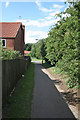
Footpath link to Beaumont Avenue
All the housing developments off either Halam Road or Westgate are linked to the spine footpath along the ridge of High Town.
Image: © Alan Murray-Rust
Taken: 19 Jun 2008
0.08 miles
5
Westgate, Southwell
Holy Trinity church spire can be seen ahead.
Image: © J.Hannan-Briggs
Taken: 30 Jan 2016
0.09 miles
6
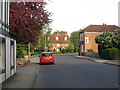
Early morning along Westgate, looking towards Sunnyside Cottages
Image: © Oliver Bell
Taken: 5 May 2014
0.09 miles
8
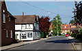
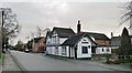
Westhorpe, Southwall NG25, Notts.
The local boundary between Southwell and the suburb of Westhorpe is just behind the photographer. Around the bend ahead is a crossroads formed by the convergence of four roads, although three of them are 'local' streets rather than main roads. The area at the centre of the crossroads was the former Market Place. "The Dumbles" public house was "The Lord Nelson" in a former life. Vehicles on this, "the Oxton Road" (the B6386), can opt to join the A6097 (the Epperstone By-Pass) a few miles further on.
Image: © David Hallam-Jones
Taken: 19 May 2013
0.10 miles
9
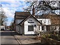
"The Dumbles", Southwell
Pub on B6386, Oxton Road, out of Southwell. Dumble is a local word for the deep cut valleys, with attendant streams, which are a feature of the high ground to the north east of Nottingham (see Image).
Image: © Oliver Dixon
Taken: 7 Mar 2014
0.11 miles
10
The Dumbles, Westhorpe
A pub that didn't do food, and at the time of our visit didn't do beer either.
Image: © Chris Morgan
Taken: 19 Jan 2015
0.11 miles