IMAGES TAKEN NEAR TO
Greet Lily Mill, Station Road, SOUTHWELL, NG25 0GL
Introduction
This page details the photographs taken nearby to Greet Lily Mill, Station Road, NG25 0GL by members of the Geograph project.
The Geograph project started in 2005 with the aim of publishing, organising and preserving representative images for every square kilometre of Great Britain, Ireland and the Isle of Man.

There are currently over 7.5m images from over14,400 individuals and you can help contribute to the project by visiting https://www.geograph.org.uk
Image Map
Images are licensed for reuse under creativecommons.org/licenses/by-sa/2.0
Notes
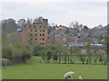
- Clicking on the map will re-center to the selected point.
- The higher the marker number, the further away the image location is from the centre of the postcode.
Image Listing (101 Images Found)
Images are licensed for reuse under creativecommons.org/licenses/by-sa/2.0
Image
Details
Distance
1
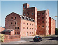
Caudwell's Mill
Former flour mill, now converted to residential accommodation.
Image: © Alan Murray-Rust
Taken: 9 Jun 2008
0.00 miles
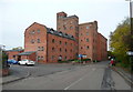
2
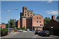
Southwell Mill, Nottinghamshire
A view of the bridge carrying the Southwell to Hockerton road over the River Greet - with the old Caudwell Mill in the background. The mill closed in 1977 and was converted into apartments in 1989.
Image: © David Hallam-Jones
Taken: Unknown
0.00 miles
3
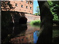
River Greet sluice, back of Caudwell's Greet Lily Flour Mill, Southwell
Image: © Chris
Taken: 23 Jun 2018
0.00 miles
4
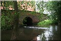
Bridge over River Greet by Caudwell's Greet Lily Flour Mill, Southwell
Image: © Chris
Taken: 23 Jun 2018
0.00 miles
5
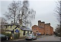
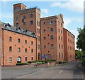
Southwell: Caudwell's Mill, 1993
Caudwell's Flour Mill was rebuilt several times after disastrous fires, getting bigger with each rebuilding. It closed in 1977. Old photographs show that the tower was once topped by a water tank. The mill was rail served, a siding from the Rolleston-Southwell-Mansfield line (which crossed Station Road behind the camera) terminating under a canopy next to the nearest (Mansard-roofed) part of the building. In 1993 Caudwell's was being converted into flats - Richard Croft's Image] shows the result, in 2007.
Image: © John Sutton
Taken: 31 Aug 1993
0.01 miles
6
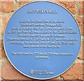
Plaque on Caudwell's Mill, Southwell
Mill next to road bridge over River Greet between Southwell and Normanton
Image: © El Loco
Taken: 6 May 2021
0.01 miles
7
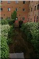
Caudwell's Greet Lily Flour Mill, Southwell
Greet is the name of the river. The mill was rebuilt after a fire in 1867, and extended in 1893 after another fire. That was when the water tower was built to supply a sprinkler system. The mill closed in 1969 and has been converted to flats.
Image: © Humphrey Bolton
Taken: 25 Oct 2015
0.01 miles
8
Caudwell's Mill
Southwell must have more blue plaques per metre than anywhere in the UK - the one on this building says; "Caudwell's Mill stands by the River Greet on the site of Southwell's medieval Burgage Mill. Much of the grain from local farms was ground here. In 1851 the Greet Mill was acquired by the Caudwell family. The mill's capacity was greatly increased. Disastrous fires in 1867, 1893 and in 1917 led to considerable re-building. By the early 1900s 'Greet Lily flour' won many awards for its fine quality. The mill closed in 1977 and in 1989 was converted to apartments."
Southwell railway station used to be about here.
Image: © Chris Morgan
Taken: 19 Jan 2015
0.01 miles
9
Caudwell's Mill, Southwell
The view across fields from Normanton.
Image: © Alan Murray-Rust
Taken: 21 Apr 2013
0.01 miles
10
Southwell, NG25, Notts.
An oft-photographed site on Normanton Road. The former Caudwell flour Mill on the south bank of the River Greet was built over the site of the medieval Burgage mill, a site purchased by Charles Caudwell in 1851. It seems that the mill was damaged by fires in 1867, 1893 and 1917 but that on each occasion it was rebuilt and the equipment upgraded. The Caudwell family were millers for four generations, after which Associated British Foods bought the mill. It closed in 1977 and was turned into flats in 1989. It is situated on the River Greet and located at the side of the Southwell Trail, a former railway route between Farnsfield and Rolleston Junction.
Image: © David Hallam-Jones
Taken: 25 May 2013
0.01 miles