IMAGES TAKEN NEAR TO
Keswick Street, NOTTINGHAM, NG2 4QW
Introduction
This page details the photographs taken nearby to Keswick Street, NG2 4QW by members of the Geograph project.
The Geograph project started in 2005 with the aim of publishing, organising and preserving representative images for every square kilometre of Great Britain, Ireland and the Isle of Man.

There are currently over 7.5m images from over14,400 individuals and you can help contribute to the project by visiting https://www.geograph.org.uk
Image Map
Images are licensed for reuse under creativecommons.org/licenses/by-sa/2.0
Notes
- Clicking on the map will re-center to the selected point.
- The higher the marker number, the further away the image location is from the centre of the postcode.
Image Listing (322 Images Found)
Images are licensed for reuse under creativecommons.org/licenses/by-sa/2.0
Image
Details
Distance
1
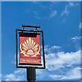
The Wheatsheaf, Sneinton Road, Nottingham
Estate pub built in 1964 by C. Howitt & Partners.
Image: © Stephen Richards
Taken: 19 Jun 2015
0.03 miles
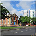
4
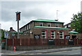
Former chapel, Sneinton Road, Nottingham
Formerly the Albion Congregational Chapel, by Thomas Oliver and William Booker, 1855-56. Grade II listed.
Now the New Albion Hostel for homeless people.
Behind is Manvers Court, one of three tower blocks built in 1963-68. When this photo was taken I think it was in the process of being re-clad (earlier view Image]).
Image: © Stephen Richards
Taken: 19 Jun 2015
0.05 miles
5
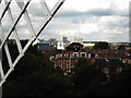
Sneinton view - 1
A foreshortened zoom view from Windmill Lane, over the rooftops of Walker Street, towards the Council House and the unpleasant high-rise blocks of Maid Marian Way.
Image: © John Sutton
Taken: 15 Apr 2011
0.06 miles
6
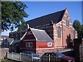
St. Alban's Church, Bond Street, Sneinton
By George Frederick Bodley
Image: © Andrew Abbott
Taken: 21 Jun 2008
0.07 miles
7
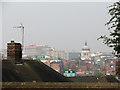
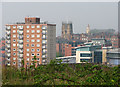
A view of the Biocity from the Green's Windmill in Nottingham
Image: © James Haynes
Taken: Unknown
0.08 miles
8
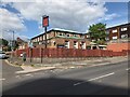
Sneinton Road: contrasts
On the left is the former Albion Congregational Church (1856). Further away are the high-rise Bentinck Court flats, built by Nottingham City Council.
Image: © John Sutton
Taken: 3 Jun 2017
0.08 miles
9
Sneinton view - 2
The view - foreshortened by a zoom lens - from Windmill Lane, outside The Queen Adelaide public house. On the horizon to the right of the tower block are the tower of St Mary's Church, the spire of the former High Pavement Unitarian Chapel (now a bar) and, in the distance, Nottingham Castle.
Image: © John Sutton
Taken: 15 Apr 2011
0.08 miles
10
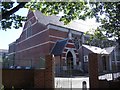
St. Alban's Church, Bond Street, Sneinton
By George Frederick Bodley.
Image: © Andrew Abbott
Taken: 21 Jun 2008
0.08 miles