IMAGES TAKEN NEAR TO
Manvers Court, NOTTINGHAM, NG2 4PF
Introduction
This page details the photographs taken nearby to Manvers Court, NG2 4PF by members of the Geograph project.
The Geograph project started in 2005 with the aim of publishing, organising and preserving representative images for every square kilometre of Great Britain, Ireland and the Isle of Man.

There are currently over 7.5m images from over14,400 individuals and you can help contribute to the project by visiting https://www.geograph.org.uk
Image Map
Images are licensed for reuse under creativecommons.org/licenses/by-sa/2.0
Notes
- Clicking on the map will re-center to the selected point.
- The higher the marker number, the further away the image location is from the centre of the postcode.
Image Listing (345 Images Found)
Images are licensed for reuse under creativecommons.org/licenses/by-sa/2.0
Image
Details
Distance
1
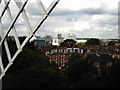
A view of the Biocity from the Green's Windmill in Nottingham
Image: © James Haynes
Taken: Unknown
0.03 miles
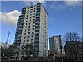
2
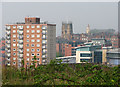
Sneinton view - 2
The view - foreshortened by a zoom lens - from Windmill Lane, outside The Queen Adelaide public house. On the horizon to the right of the tower block are the tower of St Mary's Church, the spire of the former High Pavement Unitarian Chapel (now a bar) and, in the distance, Nottingham Castle.
Image: © John Sutton
Taken: 15 Apr 2011
0.03 miles
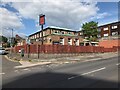
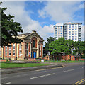
3
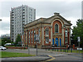
Former chapel, Sneinton Road, Nottingham
Formerly the Albion Congregational Chapel, by Thomas Oliver and William Booker, 1855-56. Grade II listed.
Now the New Albion Hostel for homeless people.
Behind is Manvers Court, one of three tower blocks built in 1963-68. When this photo was taken I think it was in the process of being re-clad (earlier view Image]).
Image: © Stephen Richards
Taken: 19 Jun 2015
0.04 miles
4
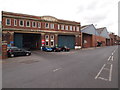
Nottingham - NG2 (Sneinton)
The Trent Barton bus company's engineering depot is one of the most prominent features of Manvers Street. It seems likely that Manvers Street was named after one of the Pierrepont family. The fifth Earl Manver's only son died as a child and Gervas Pierrepont became the sixth Earl Manvers, the title becoming extinct upon Lord Manvers's death in 1955.
Image: © David Hallam-Jones
Taken: 7 May 2012
0.04 miles
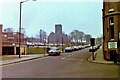
5
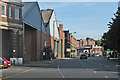
Manvers Street
Looking towards Sneinton Market from a pedestrian refuge at the corner of Pennyfoot Street. The Nottingham City Transport bus depot is on the left and in the distance the Park View Court tenement shows above the market avenues.
Image: © John Sutton
Taken: 16 Aug 2016
0.04 miles
6
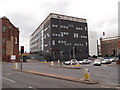
Nottingham - NG2 (Manvers St Area)
The BioCity complex features prominently at the Manvers St end of Pennyfoot St, providing business support, associated finance, laboratory facilities and office space for prestige bioscientific, pharmaceutical, medical/technical & healthcare-related companies. Thoresby Street, that runs between the former mill building and this science-oriented complex, is now gated. It has been suggested that the word "Pennyfoot" relates to a stile that previously existed at this access point into Nottingham from Sneinton, where tolls were demanded.
Image: © David Hallam-Jones
Taken: 7 May 2012
0.05 miles
9
Nottingham in the 1980s - Newark Street and St. Stephen's church
A view that is now obscured by vegetation and some new buildings. The building on the left has been replaced by newer housing, but the corner building on the right was still there in 2020.
St Stephen's Church, Sneinton is Grade II listed. The parents of D.H. Lawrence married there in 1875.
Image: © Nigel Thompson
Taken: 2 Feb 1982
0.06 miles
10
Sneinton Road: contrasts
On the left is the former Albion Congregational Church (1856). Further away are the high-rise Bentinck Court flats, built by Nottingham City Council.
Image: © John Sutton
Taken: 3 Jun 2017
0.07 miles