IMAGES TAKEN NEAR TO
Shrewsbury Road, NOTTINGHAM, NG2 4HN
Introduction
This page details the photographs taken nearby to Shrewsbury Road, NG2 4HN by members of the Geograph project.
The Geograph project started in 2005 with the aim of publishing, organising and preserving representative images for every square kilometre of Great Britain, Ireland and the Isle of Man.

There are currently over 7.5m images from over14,400 individuals and you can help contribute to the project by visiting https://www.geograph.org.uk
Image Map
Images are licensed for reuse under creativecommons.org/licenses/by-sa/2.0
Notes
- Clicking on the map will re-center to the selected point.
- The higher the marker number, the further away the image location is from the centre of the postcode.
Image Listing (69 Images Found)
Images are licensed for reuse under creativecommons.org/licenses/by-sa/2.0
Image
Details
Distance
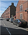
1
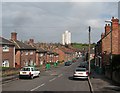
Sneinton: Shrewsbury Road
A mixture of Victorian terraces and inter-wars council houses, with the Windmill Lane tower block in the distance.
Image: © John Sutton
Taken: 20 Apr 2012
0.02 miles
2
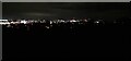
Night view of Nottingham from Roughill Wood
Image: © Roger Templeman
Taken: 25 Sep 2022
0.04 miles
3
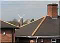
Picturesque Sneinton
A zoom view from the corner of Sneinton Boulevard and Shrewsbury Road. Green's Windmill is about half a mile to the west, in the next gridsquare.
Image: © John Sutton
Taken: 20 Apr 2012
0.05 miles
4
Once the Nottingham Suburban Railway
Looking north from Sneinton Boulevard along the filled-in cutting. The Nottingham Suburban Railway (1889-1951) lost its passenger service as long ago as 1916 - the result of competition from the city's electric trams - but continued to serve the brickworks whose owners had promoted the line. The NSR's Bridge No 5 carried Sneinton Boulevard high over the railway. Only parts of its parapet remain - see Image] for a view taken a little to the left of here.
Image: © John Sutton
Taken: 20 Apr 2012
0.05 miles
5
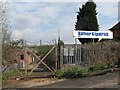
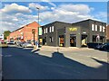
The Dale
Closed public house on Sneinton Dale.
By the design I'd say this is a former Shipstones house.
Image: © David Lally
Taken: 10 Jul 2021
0.05 miles
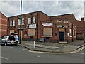
6
What's happened to The Dale
The former pub is nearly unrecognisable now it "Yum" One year and a bit prior Image
Image: © David Lally
Taken: 26 Aug 2022
0.06 miles
7
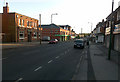
Sneinton Dale
Looking south west toward Nottingham Centre. With The Dale public house on the left.
Image: © David Lally
Taken: 19 Apr 2009
0.06 miles
8
Sneinton Boulevard: remains of Nottingham Suburban Railway bridge parapet
The Nottingham Suburban Railway (1889-1951) lost its passenger service as long ago as 1916 - the result of competition from the city's electric trams - but continued to serve the brickworks whose owners had promoted the line. The NSR's Bridge No 5 carried Sneinton Boulevard over a deep cutting now filled in. See Image] for the view to the north.
Image: © John Sutton
Taken: 20 Apr 2012
0.06 miles
9
Sneinton: Port Arthur Road
Typical late-Victorian three-storey terraces on a street which links Sneinton Dale and Colwick Road (ahead), photographed on a sunny July morning.
Image: © John Sutton
Taken: 4 Jul 2016
0.06 miles
10
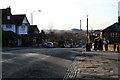
Sneinton Boulevard
The view dominated by the Nottingham incinerator.
Image: © David Lally
Taken: 30 Nov 2009
0.06 miles