IMAGES TAKEN NEAR TO
Mill View Close, NOTTINGHAM, NG2 4HL
Introduction
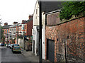
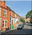
This page details the photographs taken nearby to Mill View Close, NG2 4HL by members of the Geograph project.
The Geograph project started in 2005 with the aim of publishing, organising and preserving representative images for every square kilometre of Great Britain, Ireland and the Isle of Man.

There are currently over 7.5m images from over14,400 individuals and you can help contribute to the project by visiting https://www.geograph.org.uk
Image Map
Images are licensed for reuse under creativecommons.org/licenses/by-sa/2.0
Notes
- Clicking on the map will re-center to the selected point.
- The higher the marker number, the further away the image location is from the centre of the postcode.
Image Listing (258 Images Found)
Images are licensed for reuse under creativecommons.org/licenses/by-sa/2.0
Image
Details
Distance
1

Nottingham - NG3 (Old Sneinton)
Looking along Castle Street in the direction of Sneinton Hollows with Thurgarton Street behind the photographer albeit at a distance. An interesting mock Tudor property with an unusual bay window dominates the view.
Image: © David Hallam-Jones
Taken: 12 May 2012
0.02 miles
2

Nottingham - NG3 (Old Sneinton)
Looking along Castle Street in the direction of Sneinton Hollows with Thurgarton Street behind the photographer albeit at a distance. No.9 is a large red brick property with stone window and door frames that has been boarded up for some reason.
Image: © David Hallam-Jones
Taken: 12 May 2012
0.03 miles
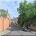
3
Sneinton Hollows
This street, one of many dating from the expansion of the area after Sneinton became part of the Borough of Nottingham in 1877, is seen from the corner of Sneinton Dale.
Image: © John Sutton
Taken: 15 Apr 2011
0.03 miles
4

Nottingham - NG3 (Old Sneinton)
A general view along Castle Street from Sneinton Hollows. Number 1, Castle Street (the white three-storey high property) hosted "The Wrestlers" pub until 1957.
Image: © David Hallam-Jones
Taken: 12 May 2012
0.04 miles
5
Sneinton: Castle Street
Looking up the hill from Thurgarton Street on a sunny June morning.
Image: © John Sutton
Taken: 3 Jun 2017
0.04 miles
6
Nottingham - NG3 (Old Sneinton)
A general view down Sneinton Hollows at the junction with Castle Street. Number 1, Castle Street (the white three-storey high property) was "The Wrestlers" pub until 1957. Hermitage Square lies at the foot of this hill.
Image: © David Hallam-Jones
Taken: 12 May 2012
0.04 miles
7

Nottingham - NG3 (Old Sneinton)
How many mothers will have trudged up and down this drive to and from Castle Street (seen between the gate posts) whilst it functioned as Trentham Lodge Health Centre? Now however, this large mid-Victorian house appears to be occupied by several families.
Image: © David Hallam-Jones
Taken: 12 May 2012
0.04 miles
8
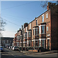
Sneinton: Victoria Avenue
Morning sunlight on the fronts of three-storey terraces typical of those built as the Borough expanded in the last twenty years of the nineteenth century.
Image: © John Sutton
Taken: 13 Apr 2016
0.05 miles
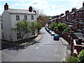
9
Up Sneinton Hollows
One of the many terraced streets built when Nottingham mushroomed in the last twenty years of the nineteenth century.
Image: © John Sutton
Taken: 4 Sep 2013
0.05 miles
10
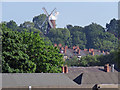
Lady Bay Bridge to Green's Windmill
A long and foreshortened zoom view through the bridge girders and over the rooftops of Sneinton. Green's Windmill was the childhood home of the self-taught mathematician George Green.
Image: © John Sutton
Taken: 3 Jun 2017
0.05 miles