IMAGES TAKEN NEAR TO
Chase Park, Daleside Road, NOTTINGHAM, NG2 4GT
Introduction
This page details the photographs taken nearby to Chase Park, Daleside Road, NG2 4GT by members of the Geograph project.
The Geograph project started in 2005 with the aim of publishing, organising and preserving representative images for every square kilometre of Great Britain, Ireland and the Isle of Man.

There are currently over 7.5m images from over14,400 individuals and you can help contribute to the project by visiting https://www.geograph.org.uk
Image Map
Images are licensed for reuse under creativecommons.org/licenses/by-sa/2.0
Notes
- Clicking on the map will re-center to the selected point.
- The higher the marker number, the further away the image location is from the centre of the postcode.
Image Listing (79 Images Found)
Images are licensed for reuse under creativecommons.org/licenses/by-sa/2.0
Image
Details
Distance
1
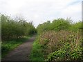
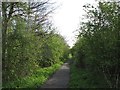
Path on a former railway embankment
After the closure of Nottingham Victoria Station in 1966 the parts of the Great Northern Railway Grantham line through Sneinton to Netherfield were abandoned. Since then, Grantham trains have used the Midland route as far as Netherfield, where the Lincoln and Grantham lines part. The GNR trackbed is now a footpath from through Sneinton from Manvers Street to Daleside Road East. This is a view towards Nottingham, with the incinerator chimney just visible in the distance above the path.
Image: © John Sutton
Taken: 20 Apr 2012
0.01 miles
2
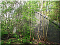
Remains of Nottingham Suburban Railway Bridge No 2
This blue brick abutment and wing wall once supported the bowstring girder bridge and embankment which carried Nottingham-bound trains on the Nottingham Suburban Railway across the Great Northern Railway Grantham line. The NSR line swung west on a 1 in 48 downward gradient and crossed the Midland line at Trent Lane before joining the GNR at Trent Lane Junction. This southern end of the NSR (1889-1951) was abandoned after wartime bomb damage to the embankment between Trent Lane and Colwick Road. Image] shows the GNR line, looking eastwards towards here.
Image: © John Sutton
Taken: 20 Apr 2012
0.04 miles
3
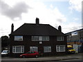
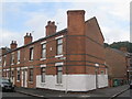
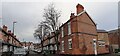
Pump Station House, Daleside Road
I have no idea why these houses, which look like typically 50s/60s semis, should be so named: a name that sounds as though it should be attached to a Victorian or Edwardian building. The houses look a little forlorn, standing as they do on a very busy road surrounded on all sides by industry.
Image: © Oxymoron
Taken: 3 Sep 2008
0.07 miles
5
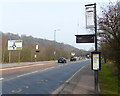
Once the railway to Grantham
After the closure of Nottingham Victoria Station in 1966 the parts of the Great Northern Railway Grantham line through Sneinton to Netherfield were abandoned. Since then, Grantham trains have used the Midland route as far as Netherfield, where the Lincoln and Grantham lines part. The GNR trackbed is now a footpath through Sneinton from Manvers Street to Daleside Road East.
Image: © John Sutton
Taken: 20 Apr 2012
0.10 miles
6
House on the corner of Kimberley Street and Whittier Road
An unusual position for a chimney.
Image: © Jonathan Thacker
Taken: 20 Jul 2012
0.11 miles
7
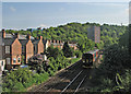
From Trent Lane footbridge
A train from Lincoln approaching the relatively new footbridge at Trent Lane, passing the backs of houses on Whittier Road. The wooded hillside in the background is Colwick Woods.
Image: © John Sutton
Taken: 16 May 2016
0.11 miles
8
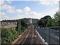
A view from the new footbridge at Trent Lane
The lines to Lincoln and Grantham divide at Netherfield. In the distance the tower block on Colwick Road is outlined against Colwick Woods. A 1950s childhood memory of going on the train to see an aunt at Rolleston is of the tin baths hanging by the back doors of the houses on Whittier Road, on the left. Image] is a view in this direction from the foot crossing the new bridge has superseded.
Image: © John Sutton
Taken: 22 Aug 2013
0.11 miles
9
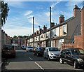
Mafeking Street at Whittier Road junction
Image: © Luke Shaw
Taken: 28 Jan 2022
0.12 miles
10
Sneinton: Kimberley Street
Like nearby Mafeking Street, its name commemorates the Boer War.
Image: © John Sutton
Taken: 4 Jul 2016
0.12 miles